


Chapter 5: Installation 5-5
5.4 Connecting to other equipment
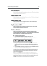
The unit transmits navigation and waypoint data on NMEA and, therefore, can
be connected to an NMEA
(1)
compatible autopilot or compatible instrument
repeater(s). The navigation data transmitted by the chartplotter is detailed in
Appendix B to this handbook.
(1)
National Marine Electronics Association (NMEA) 0183 interconnection
standard, Version 2.3 April 1998.
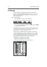
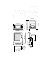
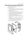
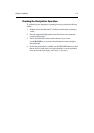
5.5 Mounting the chartplotter
Trunnion (yoke) mounting
The display unit can be conveniently mounted on a dash area, chart table,
bulkhead or deckhead, as shown in the following diagram.
1. Loosen the trunnion knobs and remove the trunnion from the display unit.
2. Mark the locations of the trunnion screw holes on the mounting surface.
3. Use the screws supplied to fix the trunnion at the marked locations.
4. Fit the unit to the trunnion, adjust the display angle and tighten the knobs.
5. Connect the Power/NMEA and GPS cables to the unit, avoiding tight
bends in the cables.
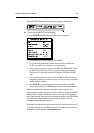
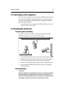
Panel mounting
CAUTION:
Make sure that there are no hidden electrical wires or other items behind
the location before proceeding. Make sure that there is sufficient rear
access for mounting and cabling. Allow at least 4cm at the right hand side
of the display to enable chart cards to be inserted and removed.