


1-2
RayChart 420/420D Chartplotter
General
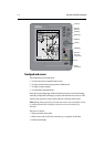
The RayChart 420 Chartplotter is waterproof and can be installed either above
or below deck. The equipment comprises:
• 6 in LCD display with Chartholder compartment for a Navionics
®
Nav-Chart
electronic chart card
• GPS receiver (RC420) or Differential/GPS (dGPS) receiver (RC420D)
The RayChart 420 Chartplotter can output GPS and Waypoint data (SOG and
COG) to operate with other equipment, eg. an autopilot or repeater instrument
connected via the NMEA 0183 interface.
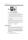
1.2 The chartplotter display
Display functions
The RayChart 420 Chartplotter includes the following functions:
• Create, Place, Move, Edit or Erase a Waypoint.
• GoTo Waypoint, Port, Facility or Cursor.
• Create, Save, Name, Edit or Follow a Route.
• Review Route and Waypoint Lists.
• Display vessel’s track on-screen; Convert a track to a route (SmartRoute).
• Set Up Alarms and Timers.
• Man OverBoard (MOB) to navigate back to a missing person or object.
• Satellite acquisition data (including a Differential GPS Setup page).
• Uses positional information from GPS (RC420) or dGPS (RC420D) to
display vessel’s position.
• The display and keys can be illuminated for night-time use.
The chartplotter includes a 64nm world map that can be used for route planning.
Detailed navigation information is displayed when a Navionics
®
Nav-Chart
card is installed.
Your vessel’s position is shown as a boat symbol pointing in your current
direction.
At the top of the chartplotter screen a status bar displays chart scale, cursor
position plus range and bearing, the vessel’s position, Speed Over Ground
(SOG) and Course Over Ground (COG).
Waypoints you have placed are displayed and the current route is shown. Data
can be viewed for current route or chart object.