


Chapter 3: Operation 3-23
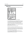
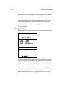
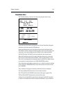
Waypoint data
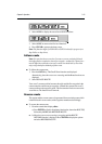
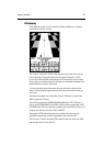
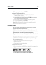
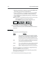
The Waypoint Data display comprises text data occupying the whole screen :
D4702_1
COG 230° T TIME 13:29 12/12/99
SOG 6.8 Kts TTG 01:03
XTE 0.5 nm ETA 14:32 12/12/99
BRG 234° T
RNG 12.4 nm
ROUTE
ROUTE 01
WPT 001
WAYPOINT
STEER STARBOARD
If a route is not selected, the ROUTE field displays NO ROUTE.
The WAYPOINT field shows the name of the waypoint. If the waypoint is part
of a route then the title field includes the waypoint index in the route. If there is
no target waypoint the text indicates NO WAYPOINT and all waypoint data is
shown as dashes, one per character. If a route is being followed and the
waypoint is not named, the text shows the waypoint number within the route (as
displayed on screen). If a GOTO Cursor or Port is in progress, the text indicates
GOTO CURSOR or GOTO ‘Port Name’.
BRG, RNG and XTE data relate to the target waypoint.
The Time refers to local time and is set in the System Set Up menu, Chapter 4.
The Time To Go (TTG) and Estimated Time of Arrival (ETA) data relate to the
target waypoint (not the whole route) and are based on the Speed Over Ground
(SOG) towards the target. If the VMG is negative, or data is not available, these
fields are replaced by dashes, one per character.
The steering instruction is STEER STARBOARD if the XTE is 0.01nm or
more to port, STEER PORT if the XTE is 0.01nm or more to starboard or ON
COURSE if XTE is less than 0.01 on either side.