


2-8
RayChart 420/420D Chartplotter
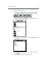
TOPSHAM
EXETER
TEIGNMOUTH
EXMOUTH
TORQUAY
DARTMOUTH
PLYMOUTH
ENPORT
SALCOMBE
PORTLAND
HARBOUR
ISLE O
CAP DE
LA HAGUE
ALDERNEY
GUERNSEY
JERSEY
PORTB
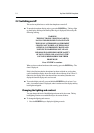
CSR 48°30.367'N
POS 1°35.636'W
128 nm
FIND SHIP ROUTES WAYPOINTS
BRG 231°T
RNG 40.91nm
Chart Boundary -
Indicates further
detail is available inside.
Shown when using
Navionics
®
Nav-Chart
card.
D4705_1
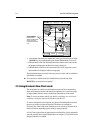
4. If no further chart detail is available then, when you press the bottom of the
RANGE key, the result depends upon whether Plotter Mode is on or off :
• If Plotter Mode is Off, the unit beeps three times and the chart scale remains
unchanged, indicating the smallest chart scale is displayed.
• If Plotter Mode is On, the scale is decreased. The vessel, waypoints, routes
and tracklines are displayed without cartography.
The chart information is restored when you return to a chart scale for which the
information is available.
To zoom out to a smaller-scale (less detailed) chart, press the top of the
RANGE key as many times as required.
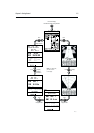
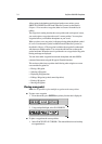
2.5 Using Navionics Nav-Chart cards
The chartplotter has a built-in world map that can be used for route planning.
Most areas (these are shown with chart box boundaries) are covered at a range
of approximately 64nm as shown on the Status Bar at the top of the screen.
Note: To ensure maximum detail for the built-in world map, two versions are
available covering the Americas and the Rest of the World.
To use the chartplotter as a navigation aid, charts with detailed information for
the area you wish to navigate are required. The charts are available on
Navionics Nav-Chart cards, each of which can store as many as 20 charts in an
electronic format, depending upon its memory storage capacity.
A Nav-Chart card provides an appropriate level of detail for a given geographic
area and scale; this data can be displayed down to a range of
1
/8nm on the screen
(height) if the data is available.