


3-30
RayChart 420/420D Chartplotter
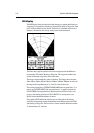
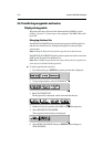
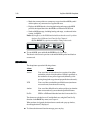
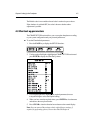
• Marks the current position as a temporary waypoint with an MOB symbol
which replaces any current active waypoint and route.
• Displays the MOB data box, showing the bearing and range to the MOB
position, the elapsed time since the MOB was initiated and COG data.
• Sends an MOB message, including bearing and range, to other units in the
system, via NMEA.
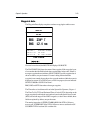
Notes: (1) A suffix (c) to the POSition data indicates that the vessel’s position
has been User Calibrated, see Chart Set Up, Chapter 4.
(2) The RANGE key operates normally to change chart scale.
To cancel MOB, press and hold the GOTO key for 2 seconds.
The chart is re-drawn at its previous scale and the MOB symbol and data box
are removed.
3.9 3.9
3.9 3.9
3.9
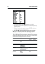
AlarmsAlarms
AlarmsAlarms
Alarms
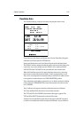
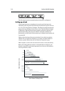
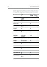
The chartplotter reports the following alarms:
Alarm Indicates:
Arrival Your vessel has arrived at the active waypoint: it has either
reached the arrival circle (the radius of which is specified) or,
has reached its closest point of approach (defined by a line
passing through the waypoint and perpendicular to the track).
XTE Your vessel has exceeded the specified distance (maximum
cross track error) from the active route leg.
Anchor Your vessel has drifted from its anchor position (set when the
alarm was turned on) by more than the specified distance.
No Fix GPS fix or Differential data has been lost for more than 30 s.
The alarms are switched on or off, and the limits set, using the Chart Set Up
function via the PAGE key menu, see Chapter 4.
When an alarm is triggered, the alarm buzzer sounds and a pop-up window,
describing the alarm, is displayed.
To silence the alarm and clear the message, press any key.