


4-2
RayChart 420/420D Chartplotter
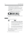
3. Use trackpad up/down to move the highlight up or down the list.
4. When the required parameter is highlighted, use trackpad left/right to step
through the settings.
5. When you have reset to the required values, press ENTER to implement
the change and return to the set up function bar.
6. Press CLEAR to clear the function bar and return to the chart display.
Note: You can return all the settings to their original factory settings, if
required, by performing a factory reset as described in Chapter 6.
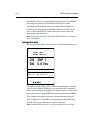
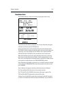
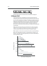
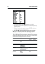
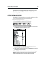
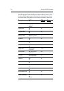
The following table lists the System menus and their options, shows the factory
default settings and provides space for you to make a note of your new settings.
Each parameter is described in the following subsections.
Menu Options Factory New
Default Setting
BEARING MODE MAGnetic TRUE
TRUE
KEY BEEP OFF/ON ON
DISTANCE UNITS NAUTICAL MILES (nm) NAUTICAL MILES
KILOMETRES (km)
STATUTE MILES (sm)
SPEED UNITS KNOTS KNOTS
KILOMETRES PER HOUR (KPH)
MILES PER HOUR (MPH)
DEPTH UNITS METRES METRES
FEET
FATHOMS
VARIATION 30°W to 30°E (1° steps) 0.0E