


Chapter 4: Setting Up the Chartplotter 4-9
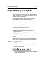
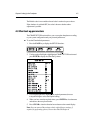
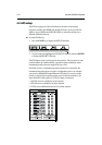
Chart boundaries
When ON, Chart boundary lines are shown on the screen. The selected setting
is retained when the unit switched off.
Depth contours <5M
When ON, depth contours less than 5 metres are shown. The selected setting is
retained when the unit switched off.
Depth contours 10M
When ON, depth contours of 10 metres are shown. The selected setting is
retained when the unit switched off.
Depth contours >20M
When ON, depth contours greater than 20 metres are shown. The selected
setting is retained when the unit switched off.
Position calibration
When ON, all position data is offset from WGS 84 by the amount of the
selected calibration and is suffixed by (c). The selected setting is retained when
the unit switched off. The default calibration offset is zero.
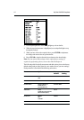
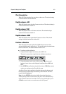
To perform position calibration:
1. Using horizontal trackpad movements, select SET CAL.
The menu is removed and a single function and help text are shown:
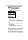
2. Using the trackpad, set the value of offset required. The distance and
bearing of cursor from vessel is displayed in the Status Bar as BRG and
RNG.
3. Press ENTER to confirm the selected offset value or CLEAR to reset the
value to zero and return to the Chart Set Up menu.
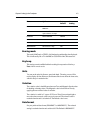
An offset of 2nm or less is applied to all position data equal to the range and
bearing between the WGS 84 position and the position entered. The menu
returns with ON highlighted.
Note: Pressing ENTER with a selected offset of more than 2nm gives a
warning message which is cleared on any key press. The Calibration Set Up
mode maintains and the user can either reselect an acceptable offset or press
CLEAR to reset the value to zero and return to the Set Up menu.