


3-2
RayChart 420/420D Chartplotter
All waypoints in the database are displayed on the screen, unless you set
SHOW WAYPOINTS to OFF in the Chart Set Up menu, as described in
Chapter 4. You can select a waypoint, either on-screen or from the list, for
editing.
The waypoint is usually placed at the cursor position and can be part of a route;
you can also place a waypoint at the vessel’s current position. You can place
waypoints before you install the chartplotter on your vessel.
When you place a new waypoint, it is displayed using either the default symbol
of a cross or an alternative symbol available from the Chart Set Up menu, as
described in Chapter 4. The waypoint is added to the waypoint list and named
with the next available number. You can use the edit functions to change the
symbol and name. When the cursor is positioned over a waypoint, the waypoint
bearing and range are displayed.
You can also transfer waypoints between the chartplotter and other NMEA
connected instruments using the Waypoint Transfer functions.
This section explains how to perform the following tasks using the on-screen
cursor and the waypoint list:
• Placing a Waypoint
• Selecting a Waypoint
• Displaying Waypoint data
• Editing a Waypoint (symbol, name & position)
• Erasing a Waypoint
• Moving a Waypoint
Placing a waypoint
Note: It is not possible to place multiple waypoints at the same position.
To place a new waypoint:
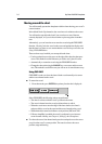
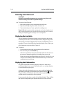
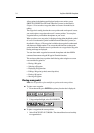
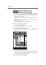
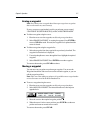
1. From chart mode, press ENTER; the primary function bar is displayed:
2. Using trackpad left/right, select WAYPOINTS.
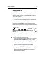
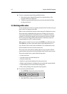
To place a waypoint at the cursor position:
1. Select PLACE WPT AT CURSOR . The selected function now has help
text appended to it: