


Magellan NAV 6500/NAV 6510 85
10-11Distance, naut. miles
12 Waypoint identifier
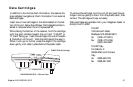
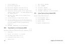
GGA Global Positioning System Fix Data
1 2 3 4 5 6 7 8 9 1011
GGA, hhmmss.ss,111.11,a,yyyyy.yy,a,x,xx,x.x,x.x,M,x.x,
1213 14
M,x.x,xxxx*hh
1 UTC of Position
2-3 Latitude - N/S
4-5 Longitude - E/W
6 GPS Quality Indicator
0 = fix not available or invalid
1 = GPS Fix
2 = Differential GPS Fix
7 Number of satellites in use
8 Horizontal dilution of precision
9 Antenna altitude above/below mean sea level
10 Units of antenna altitude
11 Geoidal separation - difference between the
WGS-84 earth ellipsoid and mean sea level
(geoid), “-” = mean sea level below ellipsoid
12 Units of geoidal separation, meters.
13 Age of Differential GPS data - Time in seconds
since last SC104 Type 1 or 9 update, null field
when DGPS is not used
14 Differential reference station ID, 0000-1023
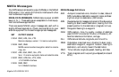
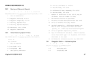
GLL Geographic Position — Latitude/Longitude
1 2 3 4 5 6
GLL,1111.11,a,yyyyy.yy,a,hhmmss.ss,A*hh
1-2 Latitude, N/S
2-3 Longitude, E/W
4 UTC of position
6 Status A = Data valid
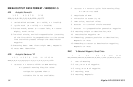
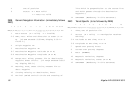
RMB Generic Navigation Information (immediately follows RMC)
1 2 3 4 5 6 7 8 9 10 11 12
RMB,A,X.XX,L,CCCC,CCCC,SSS.SS,N,XXXXX.XX,W,XXX.X,XXX.,XX.X,
13 14
A *XX
1 Status (A = valid, V = invalid)
2-3 XTE, naut. miles and direction to steer (L or
R) [If XTE exceeds 9.99 NM, display 9.99 in
field 2.]