


Magellan NAV 6500/NAV 65108
The format of the coordinates displayed can be changed. Lati-
tude and longitude (LAT/LON) are expressed in ddd mm.ss,
ddd mm.mm or ddd mm.mmm. The first option uses sec-
onds (there are 60 seconds to one minute of latitude or longi-
tude), while the second and third options use decimal for-
mat. Other formats include: UTM, OSGB and TDs.
See Navigation Setup for instructions on changing the coor-
dinate system.
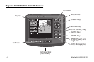
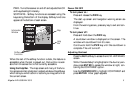
Navigating with Your Receiver
Navigation requires setting waypoints and routes. You can
either create waypoints first, using the Waypoints softkey func-
tion, and then create routes using those waypoints, or go di-
rectly to the Routes function and connect the waypoints into
a route as you create them.
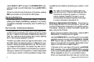
Once the route is created, it must be activated. As you get
ready to navigate, make sure the boat icon representing your
present position is active (press CTR and the boat appears at
the center of your screen, press it again and the cursor is cen-
tered). Also, make sure that the unit is computing fixes, then
it is ready to update navigation information.
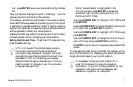
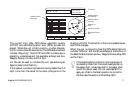
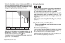
As you navigate, you can look at the map screen to see graphi-
cally how you are progressing and where you are with respect
to your planned route. You can view important navigation
data in the information window to the left of the map. You
can also use the Nav 1 screen to get complete information on
your navigation such as position coordinates, DTG, BRG,
SOG, COG, VMG, TRN, TTG and ETA to the next desti-
nation waypoint. If you wish to use other parameters for navi-
gation, you may customize the Nav 2 screen.
If you are not planning to monitor the receiver continuously,
you may choose to turn on certain alarms to warn you when
you are drifting off course or approaching your destination
waypoint.
The unit can also be connected to an autopilot. The steering
of the boat is then done automatically by the autopilot using
NMEA messages output by the unit.