


Magellan NAV 6500/NAV 651048
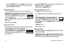
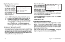
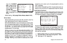
Map Configuration Functions
The Map can be config-
ured to show the objects
that best suit your navi-
gation needs. Object at-
tributes can be viewed
on the map screen if the
object is turned on in
Map Configuration.
C-MAP's cartography closely matches the source
charts and their scales in order to give the user the
most accurate digital chart navigation capability.
As you pan over the map, you may notice the scale
changing slightly even though a zoom-in or zoom-
out is not performed. This happens because you
are moving between charts that use different scales.
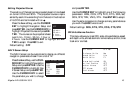
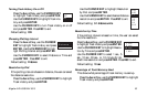
Turning Land Settings On and Off
Land icons shown on the map can be turned on and off. They
include Natural Features such as dunes, hills, vegetation, and
salt pans; Rivers and Lakes; Cultural Features, such as air-
ports, bridges, roads, railways, cables, and pipelines; and Land-
marks, such as buildings, water tanks etc.
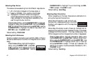
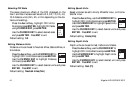
Press the Aux softkey,
use the CURSOR KEY
to highlight Map Con-
figuration Functions and
press ENTER. Use the
CURSOR KEY to high-
light Land Settings Menu and press ENTER.
Use the CURSOR KEY to select the feature you wish to acti-
vate or deactivate and press ENTER.
Use the CURSOR KEY to higlight on or off and press EN-
TER. Press ESC to exit.
Default setting: ON
Turning Marine Settings On and Off
Marine features icons shown on the map can be turned on
and off. They include Tides and Water Turbulence, Bathy-
metric Lines, Depth Areas Limits (depth contours, dredged
and intertidal areas); Bathymetrics and Soundings Range, Spot
Soundings, and Bottom Type.
Press the Aux softkey, use the CURSOR KEY to highlight
Map Configuration Functions and press ENTER.
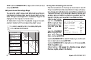
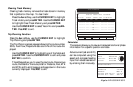
Land Settings Menu
Natural Features ON
Rivers & Lakes ON
Cultural Features ON
Landmarks ON
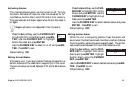
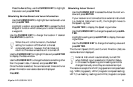
Land Settings Menu
Marine Settings Menu
Nav-Aids and Features Menu
Other Settings Menu
Chart Settings