


Magellan NAV 6500/NAV 6510 49
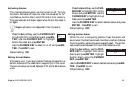
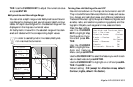
Use the CURSOR
KEY to highlight
Marine Settings
Menu and press
ENTER.
Use the CURSOR
KEY to select the
feature you wish to
activate or deactivate and press ENTER. Use the CURSOR
KEY to highlight on or off and press ENTER. Press ESC to
exit.
Default setting: ON (except for Depth Areas Limits and
Bathymetrics and Soundings Range).
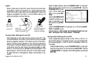
Bathymetric Lines
The Marine Settings menu under Map Configuration allows
you to turn bathymetric lines ON and OFF, and to adjust the
depth areas limit.
Bathymetric lines are taken from nautical charts and repre-
sent depth contours. To turn them ON/OFF, press Aux, se-
lect Map Configuration and press ENTER. Highlight Ma-
rine Settings and press ENTER. Highlight bathymetric lines
and press ENTER. Choose ON or OFF and press ENTER.
When you turn off bathymetric lines and return to the map,
you will notice that some contours disappear and others ap-
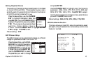
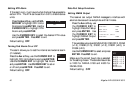
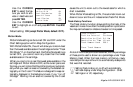
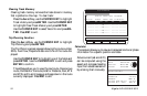
Marine Settings Menu
Tide & Water Turbulence ON
Bathymetric Lines ON
Depth Areas Limits 00033 ft
Bathymetrics and Soundings Range
00000 ft - 00033 ft
Spot Soundings ON
Bottom Type ON
pear in a paler shade of grey. Those that disappear are con-
tours which appear on the chart as discontinuous or "open."
Those contours that remain, displayed in lighter grey, are
closed contours, (i.e. forming a closed shape). Closed-con-
tour lines cannot be turned off.
Depth Areas Limits
Areas within closed depth contours are called depth areas.
Depth areas can be shaded using the Depth Areas Limits set-
ting under Map Configuration, Marine Settings. This shad-
ing gives you an instant visual cue on the chart when you
approach the depth areas limit you have selected. When you
set a depth area limit to a certain value, all areas shallower
than this value will be shaded. Depth areas deeper than the
selected value will remain unshaded.
The exact value you set as the Depth Area Limit may not be
on a contour, as contours occur at varying intervals. Conse-
quently, when you choose a depth value, the receiver defaults
to the next deepest depth area limit available. For example, if
the value you enter is 15 feet, and the adjacent closed depth
contours are at 10 and 20 feet, the receiver defaults to 20 feet
such that all area within this contour, (i.e. shallower than 20
feet), is shaded.
To set the Depth Areas Limits, press Aux, select Map Con-
figuration and press ENTER. Highlight Marine Settings and
press ENTER. Highlight Depths Areas Limits and press EN-