


Magellan NAV 6500/NAV 6510 97
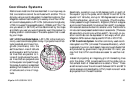
Explanation of Data Terms
DRIFT. Speed of the current. The receiver requires external NMEA
or manual input of the log speed and compass heading in order to
calculate drift.
DST. Distance to go to an active waypoint, or the distance between
two waypoints in a route leg.
SET. Direction of the current. The receiver requires external NMEA
or manual input of the log speed and compass heading in order to
calculate set.
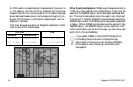
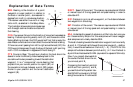
SOA. Understanding speed of advance is a little tricky but once you
do it becomes fairly simple. For this example we will use an exagger-
ated sample so as to clearly describe SOA.
The boat is heading towards the destination waypoint and is currently
at point A. If the boat had followed the original course (A
1
– destina-
tion), it would be somewhere on the line A
1
— B
1
. (The XTE for this
sample is the distance between points A and A
1
.) In 1 hour the boat is
at point B and has travelled 34 NM (equivalent to a speed of 34 knots).
Now if you project downwards to
the course the boat should be on,
you arrive at point B
1
.
Comparing the lines from points A
and B and from points A
1
and B
1
you see that while the person trav-
elled 34 NM he moved only 30 NM
along the courseline. If he moves 30
A
A
1
B
B
1
A
1
A
B
B
1
N
0°
E
90°
W
270°
S
180°
NW
315°
NE
45°
SW
225°
SE
135°
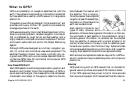
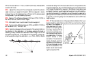
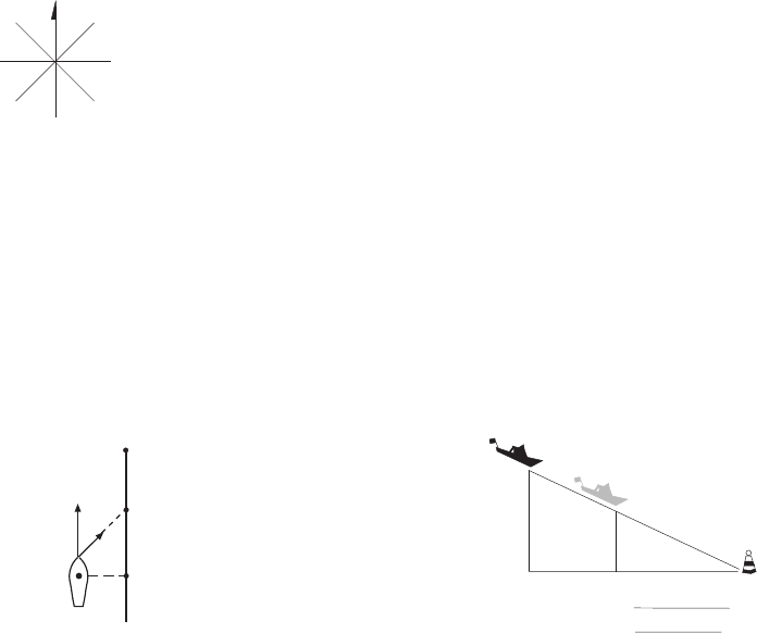
BRG. Bearing is the direction of a point
(waypoint or cursor position) in relation to
the boat or another point., as measured in
degrees from north in a clockwise direction.
The receiver uses either true north or mag-
netic north, as selected in the Setup Menu.
The illustration shows a simple compass rose
with the eight cardinal directions noted with
their bearing.
COG. Course over Ground is the direction of movement expressed as
bearing. If a boat is pointing exactly north (0°) and there are no other
factors affecting its travel, the COG would be 0° but that is rarely the
case. Water currents and wind can affect the course the boat is taking.
If there is a current passing from left to right across the boat (90°) the
COG would change even though the bow of the boat is still pointing
north. COG is measured in degrees with North being 0°.
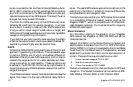
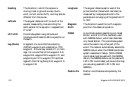
CTS. Course to Steer. The optimum direction the boat should be
steered in order to efficiently make headway back to the
courseline while also proceeding toward the destination
waypoint. It is a "compromise" course bearing that
projects from your current position to a point (B1) on
the courseline mid-way between a point (B2) perpen-
dicular to your position and the current destination
waypoint (B).
B
2
B
1
B