


Magellan NAV 6500/NAV 651094
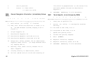
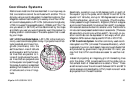
A UTM position is described by three elements; the zone it is
in, the easting, and the northing. Eastings and northings
measure how far into a zone a position is in meters. Eastings
are an east/west measurement, and correspond roughly to lon-
gitude. Northings are a north/south measurement, and cor-
respond to latitude.
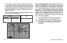
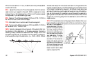
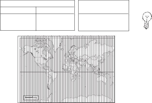
This chart shows the position of Magellan described in both
Lat/Lon and UTM coordinates.
LAT/LON UTM
DEG/MIN DEG/MIN/SEC
34˚06.58N 34˚06’35"N 11 4
23 818 E
117˚49.56W 117˚49’34"W 37
74 624 N
1511 121314
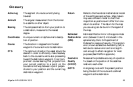
3000 Km
3000 Mi.
Scale at the Equator.
12345
180°
150°
10
120° 90°
20
60°
25
30°
30
0°
35
30°
40
60°
45
90°
50
120°
55
150°
60
180°
0°
NOTE: The area described by the UTM coordinate system extends to 84°N and to 80°S.
6789 16171819 2122232426272829 3132333436373839 41424344 46474849 5152535456575859
Other Coordinate Systems. OSGB coordinates are similar to
UTMs, but they describe only Great Britain. They must be
used with the GBR36 datum, which also describes Great Brit-
ain. This coordinate system cannot be used in any other part
of the world. The NAV 6500/6510 automatically selects the
GBR36 datum when the OSGB coordinate system is selected
in Setup. (While OSGB coordinates must be used with the
GBR36 datum, the GBR36 datum can be used with LAT/
LON coordinates; just be sure the map you are using uses
both LAT/LON and GBR36.)
If you select OSGB in the COORD SYS portion
of the Setup Menu be sure to change the map
datum back to the one you will be using (WGS84
is the default) when changing to another coordi-
nate system.