


Magellan NAV 6500/NAV 6510 93
Coordinate Systems
Specifically, a position is up to 90 degrees north or south of
the equator (up to the poles, which are 90˚N and 90˚S; the
equator is 0˚ latitude), and up to 180 degrees east or west of
the Prime Meridian, which is 0˚ longitude. (The Prime Me-
ridian passes through Greenwich, England.) Parts of a degree
are minutes; there are 60 minutes (written as 60') to a degree.
Minutes can also be divided into smaller units. Fractions of a
minute can be expressed as decimals or as seconds. (There are
60 seconds to one minute, written as 60"). So a Lat/Lon po-
sition coordinate can be expressed in two ways, which your
Magellan GPS receiver displays as 25°47.50 or 25°47’30.
UTM Coordinate System. Another commonly used coordi-
nate system is UTM (Universal Transverse Mercator), which
is generally found on land-based maps and quad sheets that
are produced by government map providers. On land, you
may find that UTM coordinates are easier to use than Lat/
Lon.
Instead of projecting an imaginary grid of intersecting lines
onto the globe, UTM projects sections of the globe onto a
flat surface. Each of these sections is called a “zone.” There
are 60 zones to cover the entire earth between 84˚N and 80˚S
(polar areas are not described by UTM). Each zone is 6˚ wide
as projected from the earth’s center.
Positions are locations that are described in a unique way so
that one locations cannot be confused with another. This is
done by using a coordinate system to describe locations. Your
Magellan receiver has the ability to use any one of four differ-
ent coordinates systems; LAT/LON (latitude and longitude),
UTM (Universal Transverse Mercator), OSGB, and TDs. The
one you select (in SETUP) will be determined by the maps
and charts you use; you would generally want the receiver to
display position coordinates in the same system that is used
by your maps.
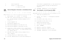
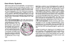
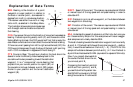
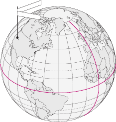
LAT/LON Coordinate System. LAT/LON is the most com-
monly used coordinate system today. It projects lines of lati-
tude (parallels) and lines of lon-
gitude (meridians) onto the
earth’s surface. Lines of latitude
are the equator and the horizon-
tal lines that are parallel to it.
Lines of longitude are the verti-
cal lines that are perpendicular
to the equator and pass through
the poles. A position is described
as being the intersection of a line
of latitude and a line of longi-
tude.
E
Q
U
A
T
O
R
0
°
P
R
I
M
E
M
E
R
I
D
I
A
N
0
°
L
a
t
i
t
u
de
L
o
n
g
i
t
u
d
e
115°00.00W
42°30.00N