


Magellan NAV 6500/NAV 651052
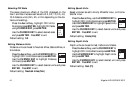
Use the CURSOR
KEY to select the fea-
ture you wish to acti-
vate or deactivate and
press ENTER.
Use the CURSOR
KEY to highlight on or off and press ENTER. Press ESC
to exit.
Default setting: ON (except Plotter Mode, default: OFF).
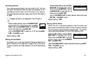
Plotter Mode
Plotter Mode setting can be turned ON and OFF under the
Chart Settings option within Map Configuration.
With Plotter Mode ON, the unit will allow you to zoom closer
than the lowest available scale in the cartridge and enter "Track
Plot Mode." If, on the other hand, the Plotter Mode setting is
turned OFF, you cannot zoom any closer than the lowest
available scale in the cartridge.
When you zoom into or near the lowest scale available in the
cartridge and Plotter Mode is OFF, as the cursor pans over
the map, you will notice that the plotter zooms out automati-
cally when you reach an area not covered by the detailed car-
tography on the C-card. This feature is designed to keep car-
tography displayed in the background even if you "run off
the edge." Panning into an area not covered by the C-card
causes the unit to zoom out to the lowest scale for which a
chart is available.
When Plotter Mode setting is ON, this automatic zoom-out
does not occur and the unit instead enters Track Plot Mode.
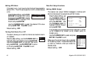
Track History Functions
The Track History Function allows plotting the track of the
vessel as it moves. How often the boat’s position is plotted on
the map can be based on distance traveled or time passed.
A total of 2000 track points can be stored, and the percentage
of these points used is shown as a percentage under Track
Memory Used. When the track memory is filled up, newly
recorded points require the unit to automatically erase points
that were first recorded.
Setting Track History on or off will automatically
set track display under Map Configuration - Chart
Settings on or off, respectively.
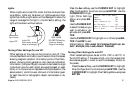
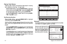
Track History ON
Plotting Interval Distance
Resolution by Dist. 0.1 Nm
Resolution by Time 10 sec
Track Memory Used 001%
Clear Track Memory
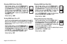
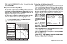
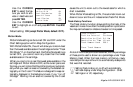
Chart Settings
Lat/Lon Grid ON
Chart Boundaries ON
Waypoint Icons ON
Track Display ON
Plotter Mode OFF