DATA INPUT AND OUTPUT
CONNECTIONS
In order for the
GlobalMap
1000
to show
position
information,
it
requires
navigation
data from
either
a
Loran-C, Decca,
or GPS receiver than can
send the data in
NMEA 0183 version 1.5 or 2.0 format. If the NMEA
input
is not
used,
then the
Lowrance LGC-1 GPS receiver can be used.
The
wiring
connections for the NMEA 0183 version 1.5 are different than
the ones used
forthe NMEA 0183 version 2.0. If
you
are
using
version
1.5,
then
use
the
green
and black wires on the
GlobalMap's powercable.
If
you
are
using
version
2.0,
then
you'll
be
using
the four shielded wires
on the
GlobalMap's
power
cable.
If
you're using
the
Lowrance LGC-1 GPS
module, simply plug
its
cable
directly
into the
in-line connector on the
GlobalMap's power
cable. This
sends
navigation
data
directly
to the
GlobalMap
without
using any
NMEA
input.
You
can,
if
desired,
use either NMEA
output
to drive another device
while
using
the LGC-1 as an
input.
The
GlobalMap
1000 also has the
provision
fora
DGPS beacon receiverforuse with the LGC-1 GPS module.
TO
NMEA 0183
VERSION 2.0
INTER FACE
(FOUR
SHIELDED
WIRES)
indicates what the
possible
er-
ror is. This
feature should al-
ways
be reset to zero
(0)
when
finished with that chart.
For
example,
suppose you
are
stopped
at a
location that is
accurately
marked on a
chart.
Your
unit shows a
longitude
position
that is .010
degrees
less than the one on the chart.
Using
the Position Correction
Factor
(PCF)
Offset
feature,
you
makethe unit read the same as the
chart.
If
you
move,
the unit will
continuously
add the
change
to all
position
displays.
This makes it more
closely
match the datum used
by
the chart.
For this
reason,
you
should be careful when
entering
the PCF offset. This
offset is saved in
memory.
It doesn't
change
when the unit is turned off.
However,
a Preset does erase the PCF factor.
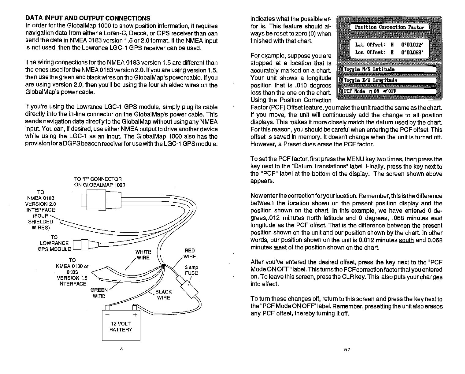
To set the PCF
factor,
first
press
the MENU
key
two
times,
then
press
the
key
next to the "Datum Translations label.
Finally, press
the
key
next to
the "PCF" label at the bottom of the
display.
The screen shown above
appears.
Nowenterthe correction
foryour
location.
Remember,
this isthe difference
between the location shown on the
present position display
and the
position
shown on the chart. In this
example,
we
have entered 0 de-
grees,.012
minutes north latitude and 0
degrees,
.068 minutes
east
longitude
as the PCF offset. That is
the
difference
between the
present
position
shown on the unit and our
position
shown
by
the chart. In other
words,
our
position
shown on the unit is 0.012 minutes south
and 0.068
minutes
wt
of the
position
shown on the chart.
After
you've
entered the desired
offset, press
the
key
next to the "PCF
Mode ON OFF" label. Thisturns the
FCFcorrection
factorthatyou
entered
on. To leave this
screen, press
the CLR
key.
This also
puts
your changes
into effect.
To turn these
changes
off,
return to this screen and
press
the
key
next to
the "PCF Mode ON OFF" label.
Remember, presetting
the unit also
erases
any
PCF
offset,
thereby turning
it off.
TO"P"OONNECTOR
ON
GLOBALMAP 1000
LOWRANCE
OPS MODULE
To
NMEA
0180
or
0183
VERSION 1.5
INTERFACE
4 57
PDF compression, OCR, web-optimization with CVISION's PdfCompressor


