To
stop
the
GlobalMap
1000
__________________________
rom
drawing
the
plottrail, press
_____
the
key
next to the "Trail
Re-
cording"
label. The
GlobalMap ____________________________
1000 not
only
will
stop
drawing
____________________________
the
plot trail,
but also will
not
keep
track of it in
memory.
If
____________________________
youwishtotemporarilystopthe
Hacard
by
g"Dist.
n
TiMe
o
Both
plot trail,
but
wish
to resume its
(Time
Inverual ... I
second
display
at a later
time,
showing
the nath "ou've
taken then
(Distance
Interval ... a1mi
I- J '
.
________________________________
press
the
key
next to the "Trail
Display"
label. This
turns the
plot
trail
off,
but the
GlobalMap
keeps
it in
memory.
If
you
turn the trail
display
on
again,
it will show
your
entire
plot
trail
(if
there's
enough memory.)
The
GlobalMap
1000 has acertain amount of
memory
reserved forthe
plot
trail. If
it runs out of
memory,
then it will
continue to draw the
plot
trail,
but
foreverydotitplacesattheendofthetrail,
itwill eraseone
atthe
beginning.
When the unit is turned on for the first
time,
the units
plot
trail
settings
are
optimized
for the
typical
user.
The trail is recorded
by
the distance
travelled,
which is
presetto
drawone dot
everyO.001
mile. In
otherwords,
everytime you
move .001
mile,
the unit
places
a dot on the trail behind
your
present position.
The distance can be
changed
from 0.001 to 10 miles
by
pressing
the
key
next to the "Distance Interval"
menu. The number at the
far
right
of that label shows the
distance interval
currently
in use. Once
you
press
the
key
next to that
label,
a new
menu
appears.
Press the
key
next
to the desired distance
interval. The unit returns to the Trail Plotter menu,
If
you
wish to
update
the
plot
trail based on time instead of
distance, press
the
key
next to
the
"Record
by"
label to move the check markfrom 'Dist."
(distance)
to
"Time".
The defaulttime
update
is onesecond.
TheGlobalMap
1000 will
place
a dot on the
trail once
every
second,
regardless
of distance
travelled. This
update
time is
changeable
from one second to 30 minutes
by pressing
the
key
nextto
the "Time Interval" label. The time shown in
this
label shows the interval
currently
selected. Once
you press
the
key
next
to that
label,
a new
menu
appears
with the time selections. Press the
key
next to the desired time. The
unit returns to the Trail Plotter menu.
The
GlobalMap
1000
can also
updatethe plottrail using
both distance and
time.
Forexample,
ifthetime
interval is one second andthe distance is one-
tenth
mile,
It will
place
a
dot on the trail
every
second and
everytenth-mile
travelled.
C.D.l.
Range
To
change
the C.D.I.
range,
press
the MENU
key,
then
press
the
key
next tothe "Steer-
ing Range"
label. The screen
shown at
right appears.
Now
press
the
key
next to the de-
sired distance. The
GlobalMap
returns to the
steering display
with the new 0.0.1.
range
in
use.
a
1.IJIJni
-
2.OOmii
rr———
5.OOmi
-
laoni
A
fasterway
to
change
the
0.0.1.
range
is to
simply press
the ZOOM IN or
ZOOM OUT
keys
while the steer
screen is
displayed.
Each time
you press
one of these
keys,
the 0.0.1.
range
increases or
decreases,
depending
on
which
key you press.
To clear the
plot
trail on
the
steering
screen,
simply press
the CLR
key.
Pressing
the STEER
key
atthe bottom of the unitwhilethe
steering
screen
is
displayed
changes
all of the boxes shown
atthetop
of the
display. Again,
all of these
displays
can be
changed
or
rearranged by
the user in
virtually
any
combination.
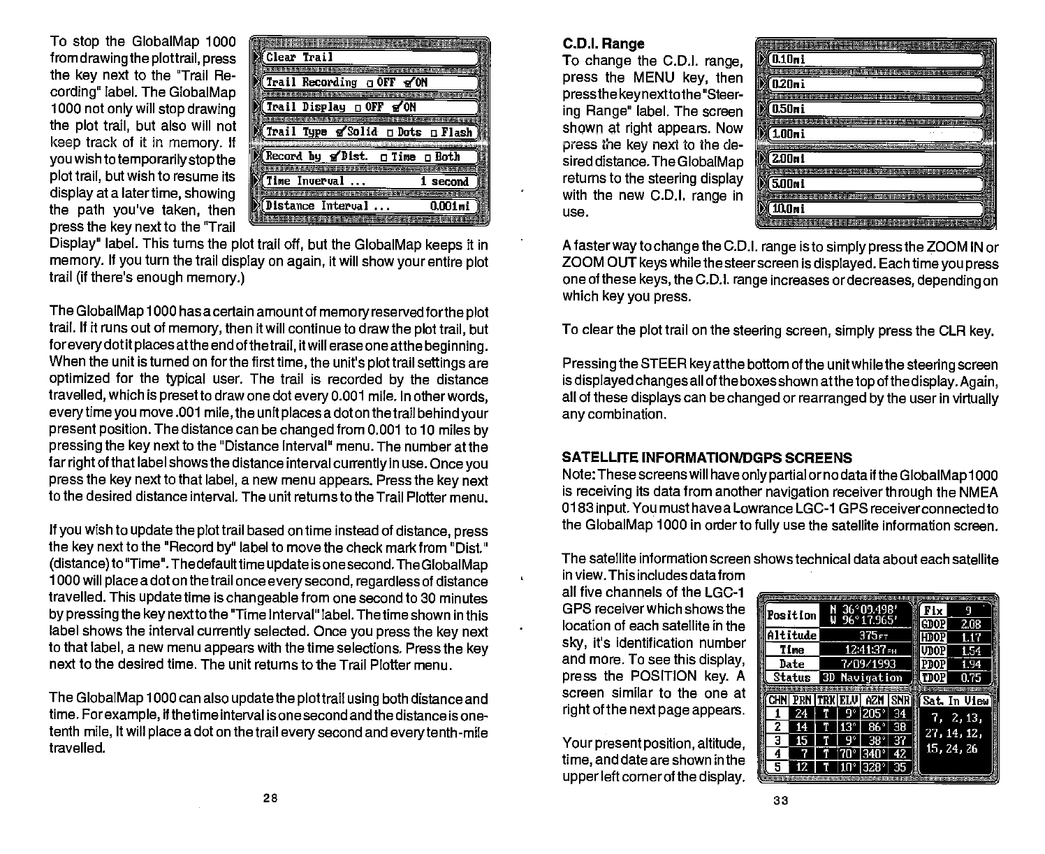
SATELLITE INFORMATION/DGPS SCREENS
Note: These screenswill have
only partial
or no data if the
GlobalMap
1000
is
receiving
its data from another
navigation
receiver
through
the NMEA
0183
input.
You must have a Lowrance LGC-1 GPS receiverconnected
to
the
GlobalMap
1000 in order to
fully
use the satellite information
screen.
The satellite information screen shows technical data about each
satellite
in
view. This includes data from
all five
channels
of the LGO-1
_______
GPS receiverwhich shows the
______
location of each satellite in the ______
sky,
it's identification number _____
and more. To see this
display,
_____________________
______
press
the POSITION
key.
A
___________________ _________
screen similar to the one at
right
of
the next
page appears.
O
24 T 9!) 205) 34
O
14 T iT 86' 38
015
1 P 38'a?
fl
7 1 70) 340) 43
o
12 1 lii' 328' 35
Clear Trail
Trail
Recording
a OFF
'ION
Trail
Display
o OFT 'ION
Trail
Type 'ISolid a
Dots
a Flash
fl.lUni
O.2IJrii
O.5Oni
H 36°09.498'
vn-ar!Ti
U 96°I7.965'
_________
375rr
fltF1 12:41:37
fl
7/09/1993
LLfl73D
Navigation
E2
2.08
tTh
1.1?
WN
154
F2JN
1.94
IE1
U.75
Your
present position,
altitude,
time,
and
date are shown in the
upper
left cornerof the
display.
28
33
pSat.
In Vie
PDF compression, OCR, web-optimization with CVISION's PdfCompressor


