


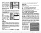
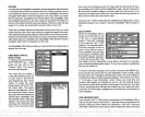
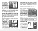
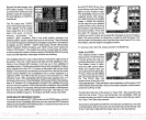
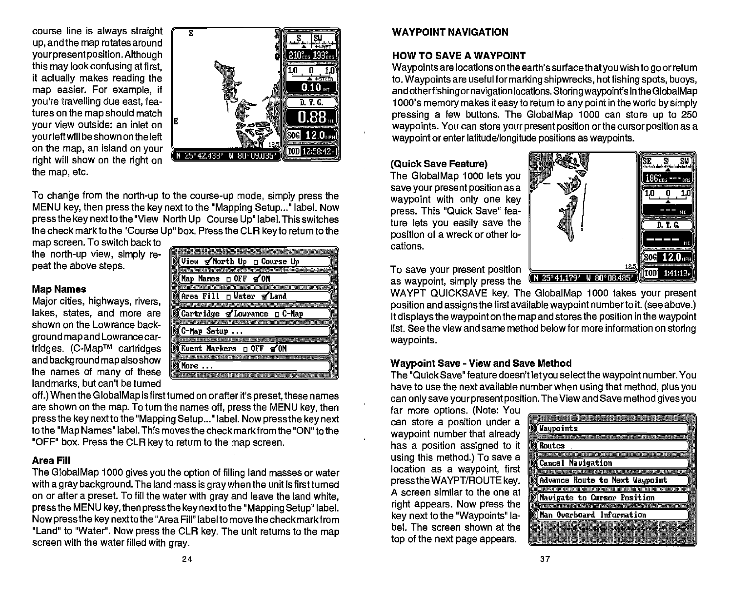
course line is
always straight g
WAYPOINT NAVIGATION
up,
and the
map
rotates
around
yourpresent position.
Although
this
may
look
confusing
at
first,
it
actually
makes
reading
the
map
easier. For
example,
if
you're travefling
due
east,
fea-
tures on the
map
should
match
your
view outside: an inlet
on
your
left will be shown on
the left
__________
on the
map,
an island on
your
right
will show on the
right
on
the
map,
etc.
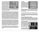
To
change
from the
north-up
to the
course-up
mode,
simply press
the
MENU
key,
then
press
the
key
next to the
"Mapping Setup..."
label. Now
press
the
key
next to the "View North
Up
Course
Up"
label. This switches
the check markto the "Course
Up"
box. Press the CLR
key
to return to the
map
screen. To switch back to
__________________________
the
north-up
view,
simply
re-
peat
the above
steps.
____________________________
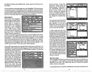
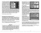
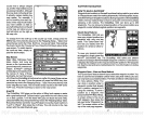
Map
Names
Major
cities,
highways, rivers,
______________________________
lakes, states,
and more
are
shown on the Lowrance back-
ground map
and
Lowrance car-
tridges. (CMapTM
cartridges
______________________________
and
background
map
also show
the names of
many
of
these
landmarks,
but can't be turned
off.)
When the
GlobalMap
is firstturned on or after it's
preset,
these names
are shown on the
map.
To turn the names
off,
press
the MENU
key,
then
press
the
key
next to the
"Mapping Setup
label. Now
press
the
key
next
to the
"Map
Names" label. This
moves the check markfrom the "ON" to the
"OFF"
box.
Press
the CLR
key
to return to the
map
screen.
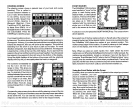
Area Fill
The
GlobalMap
1000
gives
you
the
option
of
filling
land masses or water
with a
gray background.
The land mass is
graywhen
the unit is first turned
on or after a
preset.
To
fill the water with
gray
and leave the land
white,
press
the MENU
key,
then
pressthe key
nextto the
"Mapping Setup"
label.
Now
press
the
key
nextto
the "Area Fill" label to move the check markfrom
"Land" to "Water". Now
press
the CLR
key.
The unit returns to the
map
screen with the water filled
with
gray.
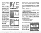
HOW TO SAVE A WAYPOINT
Waypoints
are
locations
on
the earth's
surfacethatyouwish
to
go
or return
to.
Waypoints
are useful for
marking shipwrecks,
hot
fishing spots, buoys,
and
otherfishing ornavigation
locations.
Storingwaypoint's
inthe
GlobalMap
1000's
memory
makes it
easy
to return to
any point
in the world
by simply
pressing
a few buttons. The
GlobalMap
1000 can store
up
to 250
waypoints.
You can store
your present position
or the cursor
position
as a
waypoint
or enter
latitude/longitude positions
as
waypoints.
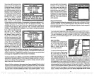
(Quick
Save
Feature)
The
GlobalMap
1000 lets
you
save
your present position
as a
waypoint
with
only
one
key
press.
This "Quick Save" fea-
ture lets
you easily
save the
position
of a wreck or other lo-
cations.
To save
your
present position
as
waypoint, simply press
the
WAYPT QUICKSAVE
key.
The
GlobalMap
1000 takes
your present
position
and
assigns
the first available
waypoint
numberto it.
(see above.)
It
displaysthe waypoint
on the
map
and stores the
position
in the
waypoint
list. See the view and same method belowfor more information on
storing
waypoints.
Waypoint
Save
-
View and Save Method
The "Quick Save" feature doesn't let
you
selectthe
waypoint
number.
You
have to use the next available number when
using
that
method, plus
you
can
only saveyour present position.
The View and Save method
gives you
far more
options. (Note:
You
________________________________
can store a
position
under a
waypoint
number that
already _______________________________
has a
position assigned
to it
__________________________________
using
this
method.)
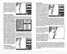
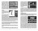
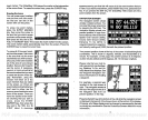
To save a
location as a
waypoint,
first
_________________________________
press
the WAYPT/ROUTE
key.
___________________________
A screen similar to the one at
right appears.
Now
press
the
_______________________________
key
next to the
"Waypoints"
la
_______________________________
bel. The screen shown at the
top
of
the next
page appears.
________________________________
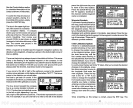
rz:
(Ilaypo
juts
J
Cancel
Navigation
—-
Haute to Next
Waypoint
;
(Navigate
to Cursor Position
(Han
Overboard Information
J
)
Ii88
IS
Z5°4143R' li ¶J°1J9.035'
12.0
1Z:58:42p
_
View g'North
Up
a Course
Lip
(Nap
Manes a OFF 'ION
(Area
Fill
a
Water
'ILand
(Cartridge
ILourance o
C—Nap
C—Nap Setup
(Event
Narkers
a
OFF
ION
(Hare
N 2541,1?9' V 80°II8.405'
12.O,
24 37
PDF compression, OCR, web-optimization with CVISION's PdfCompressor