


60
Reference
Driving on a Route
Once you have created a route and have selected Start Navigation, the StreetPilot will give
you progressive guidance. Just as on a Direct Goto, the Map Page and the Road Sign Page are the two
primary sources of this guidance.
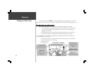
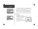
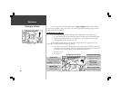
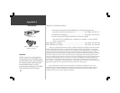
The Map Page on a Route
! The Driving Status at the top of the page tells you what direction to go (North, South,
etc.), as well as the name of the road and the name of the next road or turn (top left picture).
! A wide route line traces the path to your destination. This line may or may not follow
roads, depending on how the route was built.
If the Map Page (picture below) is set up to show Navigation Info (as opposed to the Full
Screen Map), the following information is also shown:
! A Direction to Go pointer: the direction from your current location to the next turn, based
on the direction you are driving. When the “Approaching Waypoint Alarm” activates prior
to reaching a turn, this area changes to show the direction of the turn.
! The Distance to Go.
! The Time to Go.
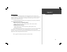
Map Page on a Route
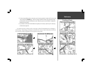
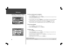
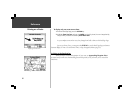
The Map Page at a Route Turn
Next Turn Direction
Compared to the current
leg of the route
Time to Next Turn
Based on distance to go.
Distance to
Next Turn
Along route line
Turn Alert
Direction to turn and
street name (press
ENTER to acknowledge)
Route Line
May or may not
follow roads.