


6
Quick-Start
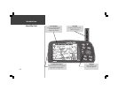
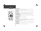
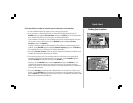
Finding Your Location
Finding Your Location
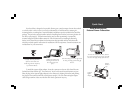
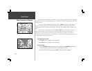
The first time you use your StreetPilot to navigate, take it outside or properly mount it on the
dashboard of a vehicle in an open area with a clear view of the sky. Make certain the antenna is pointing
up. The StreetPilot also has the option of using a Simulator Mode which does not require reception of
GPS satellite signals. Refer to page 8.
When stationary, your Street Pilot should be able to calculate your position within five (5)
minutes after being turned on with a clear view of the sky.
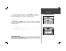
The Global Positioning System (GPS) is a system of 24 satellites that circle the Earth twice a day
in a very precise orbit and transmit information to Earth. The StreetPilot must continuously receive
signals from at least three of these satellites to calculate your location and track your movement. At
times, additional satellites may be needed to determine your location.
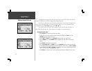
Your GPS receiver can only receive signals from satellites which are above the horizon, so it
needs to know what satellites to look for at any given time. In order to determine which satellites are
above the horizon, your GPS needs to either be told its general location (“initialized”) or given the
opportunity to find itself. Once you initialize the unit to a location, it will typically compute a position
within a few minutes.
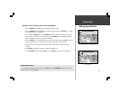
Initialization is only necessary under the following conditions:
! The first time you use your StreetPilot (new from the factory).
! After the StreetPilot has been moved more than 500 miles (with the power off) since the
last time you used it.
! If the StreetPilot’s memory has been cleared and all internally stored data has been lost.
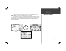
Once the StreetPilot has calculated your location, you will have anywhere from three to 12
satellites in view. The receiver will then continuously select the best satellites in view to update your location.