


Quick-Start
7
If the StreetPilot is unable to calculate your location after a few minutes:
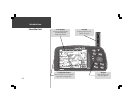
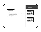
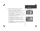
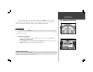
1. A ‘Poor Satellite Reception’ box appears on the screen (top right picture).
2. If you are indoors, or would otherwise like to simulate GPS location and motion, use the
ROCKER keypad to highlight Start Simulator and press the ENTER key. The Simulator Mode
starts, and the StreetPilot returns to the page it was showing beforehand.
If the StreetPilot is brand new, or if the StreetPilot unit has been moved hundreds of miles since
the last time it tracked a GPS location, use the ROCKER keypad to highlight Set New
Location and press the ENTER key.
If neither of the above applies, and you would like the StreetPilot to continue looking for GPS
satellites, use the ROCKER keypad to highlight Continue Acquiring and press the ENTER key.
The StreetPilot will return to the page is was showing beforehand.
3. If you chose Set New Location, a new box appears asking what method you would like to use
for aiding the StreetPilot in determining your location.
4. If you know the general area of the continent where you are located, you can speed up the
calculation of your location by pointing to that area on a map. Use the ROCKER keypad to
highlight Use Map (top right picture) and press the ENTER key.
Otherwise, use the ROCKER keypad to select AutoLocate and press the ENTER key. The
StreetPilot will determine where you are located. This process is fully automatic and under
normal circumstances will calculate your position in 3-5 minutes when the unit has a good view
of the sky and is stationary.
Using the Map to Set Location
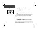
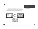
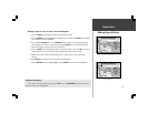
5. If you chose Use Map, a continental map is displayed with an arrow pointer on it (lower right
picture). Use the ROCKER keypad to move the arrow pointer to your approximate location and
press the ENTER key. Remember, you do not need to be exact. The StreetPilot only needs an idea
where you are within a few hundred miles.
Choosing ‘Use Map’
Finding Your Location