


30
Reference
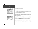
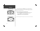
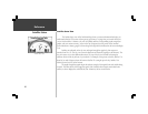
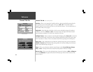
Satellite Status
Satellite Status View
The Satellite Status view of the Dashboard Page shows you status information that helps you
understand what the GPS receiver is doing at any given time, it is a page that you can refer back to as
you use the StreetPilot. It features a sky view of available satellites, corresponding signal strength bar
graphs, and your current accuracy. Just as in the Trip Computer view, the power source (external
power indication or battery gauge) is shown along with a light bulb to indicate that the screen backlight
is on.
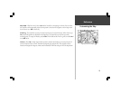
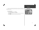
Satellites are indicated on the sky view and signal strength bar graphs by their respective
number, from 01 to 32. The sky view shows the direction and elevation (angle above the horizon). The
sky view rotates as you drive different directions. The top of the sky view should be showing the
satellites that are in the sky in front of your vehicle. For example, in the picture at the left, satellite 17 is
ahead of you and 45 degrees above the horizon. Satellite 21 is straight up in the sky. Satellite 16 is
behind you and very low to the horizon.
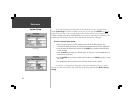
The signal strength bar graphs depict the relative strength of the signals from each satellite being
received. The taller the bar, the stronger the signal. If the StreetPilot has received certain data from a
satellite, its bar is displayed as solid (filled in) bar. Otherwise, the bar is not filled in.
Satellite Status View