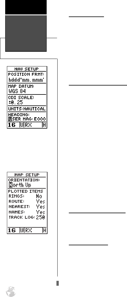
Units of Measure
The GPSCOM 170 lets you select nautical (default),
statute or metric units of measure for all speed and dis-
tance fields.
To change the unit of measure:
1. Highlight the ‘units’ field and press
E
.
2. Use the up and down arrow keys to select the desired
unit of measure. Press
E
to confirm the selection.
Magnetic Heading Reference
The GPSCOM 170’s heading information can be dis-
played referencing magnetic north (auto or user-defined),
true north or calculated grid headings. The default setting
is automatic magnetic north, which is suitable for most
applications.
To select a heading reference:
1. Highlight the ‘HEADING’ field and press
E
. Select
the desired heading preference.
2. Press
E
to confirm the selection.
To enter a user-defined magnetic heading
:
1. Select the ‘USER MAG’ option and press
E
.
2. Use the up and down arrow keys to enter the degrees
and direction of magnetic variation.
3. Press
E
to confirm the magnetic variation value.
Map Setup and Orientation
The map setup page can be accessed from the main
menu page and the moving map page. See page 54 for
details on the map setup and orientation.
TracBack Function
The next listing on the main menu page is the track
log, which can be also be accessed from the moving map
page. See page 40 for details on the tracback function.
Menu Page
Options
Reference
60
Magnetic Heading
To enter a user-defined
magnetic variation, select
the ‘User Mag’ option and
enter the desired direction
and value.
Map Setup Page
The map orientation can be
set to track up, north up, or
desired track up. The plot-
ted items options let you
define what appears on the
map display.
170 manual pages rev D 9/21/98 9:23 AM Page 60


