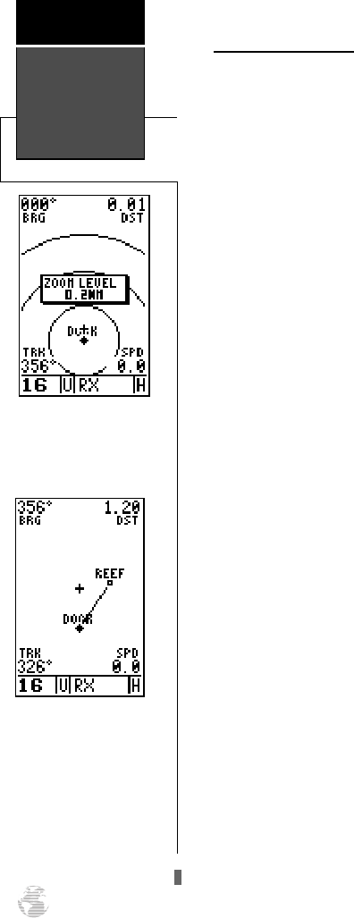
Zooming and Panning
There are three main functions you can perform from
the map page— zooming, panning, and pointing. The
moving map has 12 map scales (from 0.2 to 320 miles, or
0.5 to 600 km.) which are selected using the IN and OUT
zoom keys. These ranges are measured vertically.
To use the zoom keys:
1. From the map page, press either the IN or OUT
zoom keys.
2. To see the current map scale, press and hold either
button down. A pop-up window will display the
current scale.
The second function on the map page is the pan func-
tion, which allows you to move the map with the keypad
in order to view areas outside the current map.
To activate the pan function:
1. Use the keypad to move the map in any direction,
including diagonally.
As you begin to move the map, a crosshair will appear.
This crosshair will now serve as a target marker for the mov-
ing map. The distance and bearing to a destination will now
be replaced by the distance and bearing from your present
position to the target crosshair.
As you pan around the map, you’ll notice that the tar-
get crosshair will ‘snap’ to on-screen waypoints and high-
light the waypoint name. Once a waypoint name is high-
lighted, you can review its waypoint definition page or
execute a GOTO function right from the map page.
To review the definition page for a waypoint high-
lighted on the map page:
1. Press
E
.
To GOTO a waypoint highlighted on the map page:
1. Press
G
.
2. Press
E
to confirm the GOTO waypoint page.
To stop the panning function:
1. Press
Q
.
Moving Map
Page
Reference
52
Selecting Map Scales
To change the map scale,
press the zoom field UP and
DOWN keys.
Panning Function
During panning mode, an
on-screen crosshair will
appear. Your present posi-
tion will remain as a dia-
mond icon, with the range
and bearing to the crosshair
displayed in the top corners
of the map.
170 manual pages rev D 9/21/98 9:23 AM Page 52


