


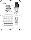
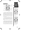
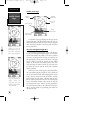
Using the Highway Page
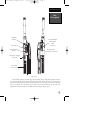
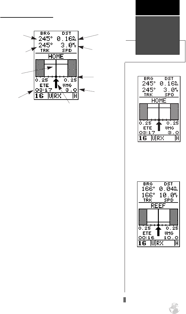
The GPSCOM 170’s highway page provides graphic
steering guidance to a destination, with an emphasis on a
straight–line course to the desired waypoint and the dis-
tance and direction you are off course. The bearing and
distance to a waypoint, along with your current track and
speed, are displayed at the top of the screen, with your
estimated time enroute (ETE) and velocity made good
(VMG), or the rate you are closing in on your destination,
shown at the bottom.
As you head toward your destination, the middle sec-
tion of the screen provides visual guidance to your way-
point on a moving graphic ‘highway’. The moving arrow
just below the course deviation scale always points to
your selected waypoint relative to the direction you are
moving.
Your present position is represented by the diamond
in the center of the course deviation scale. The line down
the middle of the highway represents your desired track.
As you navigate toward a waypoint, the highway will
actually move, indicating the direction you’re off course,
relative to the position square on the CDI scale. To stay
on course simply steer toward the center of the highway.
As you approach a way-
point, a horizontal ‘finish
line’ will move toward the
bottom of the highway.
Your present position is rep-
resented by the square in
the center of the course
deviation scale.
Using The
Highway Page
Getting
Started
11
Distance to
Waypoint
Track Over
Ground
Bearing to
Waypoint
Estimated
Time Enroute
Velocity
Made Good
Speed Over
Ground
Graphic
Highway
Course
Deviation
Scale
Pointer to selected
waypoint
170 manual pages rev D 9/21/98 9:23 AM Page 11