


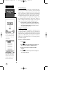
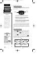
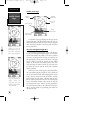
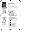

Satellite Status Page
The satellite status page displays the status of various
receiver functions. The status information will help you
understand what the GPSCOM 170 is doing at any given
time, and tell you whether or not the receiver has calcu-
lated a position fix.
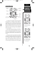
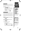
Sky View and Signal Strength Bars
The satellites are identified by letters and numbers.
The sky view and signal strength bars give you an indica-
tion of what satellites are visible to the receiver, whether
or not they are being used to calculate a position fix, and
the signal quality. The sky view in the center of the page
shows a bird’s-eye view of the position of each satellite
relative to the receiver’s last known position. The outer
circle represents the horizon (north up); the inner circle
45º above the horizon; and the center point a position
directly overhead.
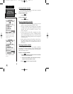
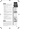
When the receiver is looking for a particular satellite,
the corresponding signal strength bar will be blank and
the sky view indicator will remain highlighted in reverse
video. Once the receiver has found the satellite, a hollow
signal strength bar will appear, indicating that the satel-
lite has been found and the receiver is collecting data
from it. The satellite number or letter in the sky view will
also change from reverse video to normal presentation.
As soon as the GPSCOM 170 has collected the necessary
data to use the satellite for positioning, the hollow bar
will become solid.
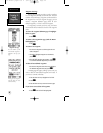
Satellites in view but not
currently in use (Q & 9)
will be displayed in reverse
video, with a corresponding
‘hollow’ signal strength bar.
Satellite Status
Page
Reference
18
Once a satellite in view is
usable for positioning, the
satellite number will
change from reverse video
and the signal strength bar
will become solid.
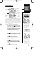
Operating
Mode
Signal Strength
Indicator Bars
Satellite
Numbers/Letters
Satellite Sky
View
Estimated
Position Error
Battery Voltage
170 manual pages rev D 9/21/98 9:23 AM Page 18