


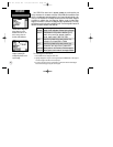
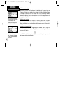

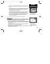

VOR Information Page
The VOR Information Page displays the identifier, facility name, city name,
region/country, position and frequency for the selected VOR. The facility type (ter-
minal, low altitude or high altitude) is also indicated. If DME or TACAN equipment
is co-located at the site, it will be indicated next to the transmitting frequency.
Likewise, if the facility broadcasts weather information, ‘WX’ will appear next to the
transmitting frequency. Position information will be in the format specified on the
Setup pages (see page 86).
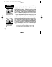
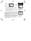
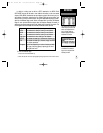
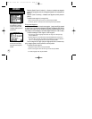
NDB Information Page
The NDB Information Page displays the identifier, facility name, city name,
region/country, position and frequency for the selected NDB. If the facility broadcasts
weather information, it will be indicated by a ‘WX’ appearing next to the transmitting
frequency.
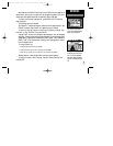
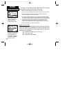
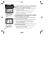
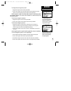
Intersection Information Page
The Intersection Information Page displays the identifier, position, region and
country for the selected intersection. The page also shows the bearing and distance to
the nearest VOR facility.
NOTE: The VOR displayed is simply the nearest facility and may not be the
facility used to define the intersection.
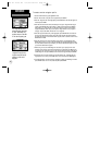
The VOR Information Page
provides complete information
about the selected VOR,
including facility name, city,
frequency and designation for
co-located DME or TACAN.
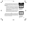
Both the NDB and VOR
Information Pages provide
‘WX’ indications if the select-
ed facility broadcasts weather
information.
52
REFERENCE
Waypoint Information Pages
?
GPS III Pilot B2 4/1/99 2:02 PM Page 52