


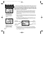

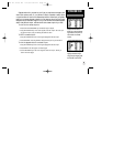
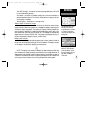
You can use the sky view to help determine if any satellites are being blocked,
and whether you have a current position fix (indicated by ‘2D Navigation’ or ‘3D
Navigation’ in the status field). You can also set the sky view to a ‘Track Up’ config-
uration, causing the top of the sky view to align along your current track heading.
When the receiver is looking for a particular satellite, the corresponding signal
strength bar will be blank and the sky view indicator will not be highlighted. Once
the receiver has found the satellite, a hollow signal strength bar will appear, indicat-
ing that the satellite has been found and the receiver is collecting data from it. The
satellite number on the sky view will appear highlighted. As soon as the GPS III Pilot
has collected the necessary data to calculate a fix, the status field will indicate a 2D
or 3D status. (For ‘2D’, you may need to enter your altitude. See page 32.)
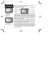
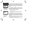
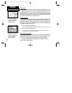
Receiver Status
Receiver status is indicated at the top left of the page. The status will be shown
as one of the following conditions:
Searching— the GPS III Pilot is looking for any available satellites in view.
AutoLocate— the GPS III Pilot is initializing and collecting new almanac data. This
process can take up to 5 minutes, depending on the satellites currently in view.
Acquiring— the receiver is collecting data from available satellites, but has not
collected enough data to calculate a position fix.
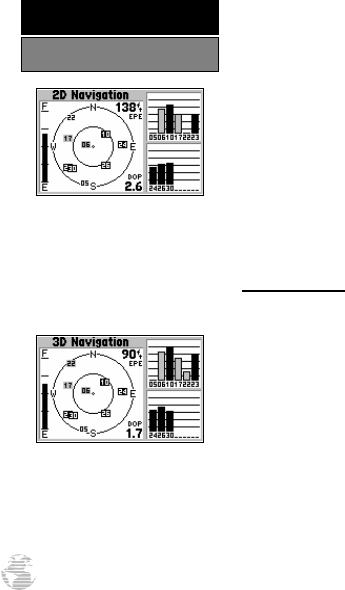
2D Navigation— at least three satellites with good geometry have been locked
onto and a 2-dimensional position fix (latitude and longitude) is being calculat-
ed. ‘2D Diff’ will appear when you are receiving DGPS corrections in 2D mode.
3D Navigation— at least four satellites with good geometry have been locked
onto, and your position is now being calculated in latitude, longitude and alti-
tude. ‘3D Diff’ will appear when you are receiving DGPS corrections in 3D mode.
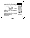
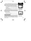
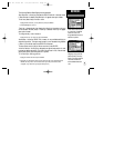
‘2D Navigation’ means the
GPS III Pilot has determined a
horizontal position (latitude/
longitude), but is unable to
determine altitude. Additional
satellites may be needed.
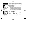
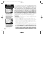
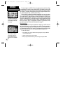
‘3D Navigation’ means the
GPS III Pilot has determined
a horizontal and vertical posi-
tion (latitude, longitude and
altitude). The receiver is
ready for navigation.
28
REFERENCE
Satellite Status Page
GPS III Pilot B2 4/1/99 2:02 PM Page 28