


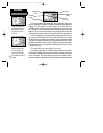

To create a vertical navigation profile:
1. Select the Main Menu by pressing MENU twice.
2. Select ‘Vertical Nav’ using the rocker keypad and press ENTER.
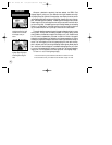
3. With the ‘Target Altitude’ field highlighted, press ENTER. Enter the desired target alti-
tude and press ENTER.
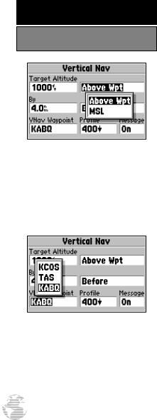
4. With the altitude reference field (immediately to the right of ‘Target Altitude’) high-
lighted, press ENTER. Select ‘Above Wpt’ or ‘MSL’ (as desired) and press ENTER.
‘Above Wpt’ will use the altitude of a destination airport as stored in the internal
Jeppesen database. ‘MSL’ lets you set a specific target altitude for any waypoint
category: airport, VOR, NDB, intersection or user waypoint.
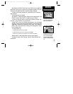
5. With the waypoint distance ‘By’ field highlighted, press ENTER. Enter an offset dist-
ance from the destination waypoint where the target altitude should be reached. If
the target altitude occurs at the destination waypoint, enter a distance of zero. Press
ENTER when finished.
6. With the offset direction field (immediately to the right of ‘By’) highlighted, press
ENTER. Select ‘Before’ or ‘After’ and press ENTER. This setting designates whether
the offset distance defines a point before you reach the destination waypoint or after
you reach the destination waypoint.
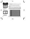
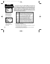
7. When using a route, the ‘VNav Waypoint’ field allows you to specify which route
waypoint will be used for the vertical navigation profile. By default, the GPS IIIPilot
will select the last waypoint in the route. To select a different waypoint, highlight the
‘VNAV Waypoint’ field, press ENTER, select the desired waypoint and press ENTER.
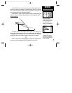
8. The default profile utilizes a 400 foot-per-minute descent rate. To change the rate,
highlight the ‘Profile’ field, press ENTER, enter a new rate and press ENTER again.
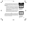
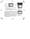
9. To enable/disable all vertical navigation messages, highlight the ‘Message’ field and
press ENTER. Select ‘On’ or ‘Off’ (as desired) and press ENTER.
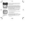
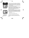
Your target altitude can be
defined as height ‘Above Wpt’
or ‘MSL’. ‘Above Wpt’ only
applies to airports. Use ‘MSL’
for all other waypoint types.
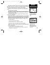
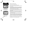
When using a route, vertical
navigation can apply to any
waypoint along the route by
selecting it as the ‘VNAV
Waypoint’.
44
REFERENCE
Vertical Navigation
GPS III Pilot B2 4/1/99 2:02 PM Page 44