


Working from the Map Page is a simple process that centers around the use of
the cursor. Controlled by the rocker keypad, the cursor is an important tool allow-
ing you to pan to other areas on the map display, view waypoint information, create
waypoints, specify a GOTO target and create routes. To get a feel for using the Map
Page and the cursor, try the following exercise:
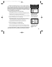
1. Using the rocker keypad to move the cursor, try following a highway (or other fea-
ture) near your position. Simply press and hold one side of the rocker keypad to
move more quickly. Notice how a data field appears above the map, showing the
bearing and distance from present position to the cursor, along with the latitude/
longitude of the cursor.
2. Using the rocker keypad, continue moving the cursor in any direction until you find
an airport or navaid. Once you find one, place the cursor over that waypoint so that
its identifier is highlighted.
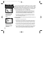
3. Press ENTER to view the database information for the selected waypoint. If an air-
port is selected, use the LEFT/RIGHT keys on the rocker keypad to select between
‘Airport’, ‘Runway’ and ‘Comm’ information pages.
4. When finished reviewing the information press QUIT to return to the Map Page.
(Pressing QUIT a second time will end the panning operation and return the map to
your present position. For now, we’ll stay in panning mode and leave the selected
waypoint highlighted on the map.)
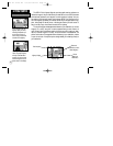
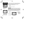
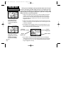
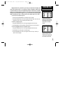
Use the rocker keypad to pan
to other areas on the map
display. When panning, an
on-screen cursor appears for
reference.
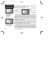
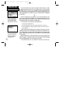
Place the cursor over an on-
screen airport or navaid to
highlight the item, then press
ENTER to view database
information for the selected
item.
20
SIMULATOR TOUR
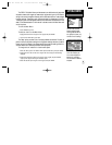
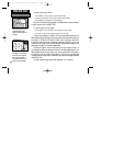
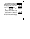
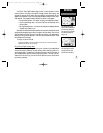
Viewing Waypoint Info
Waypoint
Identifier Field
Waypoint
Symbol Field
Waypoint Position
‘File Tabs’ for
other info types
GPS III Pilot B2 4/1/99 2:02 PM Page 20