


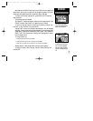
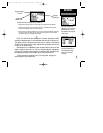

Your GPS III Pilot uses a built-in Jeppesen database to provide position and
facility information for thousands of airports, VORs, NDBs and intersections. Each
facility in the database is stored as a waypoint, with its own latitude/longitude, iden-
tifier (up to six letters and/or numbers) and other pertinent information. Waypoint
information is available from the ‘Waypoints’ selection under the Main Menu.
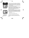
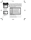
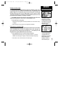
Waypoint information is divided into categories (each represented by a ‘file tab’),
with different types of information available for each. The following table lists the file
tabs and information available under each tab:
Airport Identifier, city/state, name, position, elevation, fuel
Runway Length, width, orientation, surface, lighting, diagram
Comm Frequencies for: ATIS, pre-taxi, clearance, ground,
tower, unicom, multicom, approach, departure,
arrival, class B, class C, TMA, CTA, TRSA
VOR Identifier, city/state, facility name, position, freq.,
indication of co-located DME or TACAN
NDB Identifier, city/state, facility name, position, freq.
Int Intersection name, region/country, nearest VOR
User Wpt Name, position, user comments, reference waypoint
User List Name, symbol, total number of user waypts created
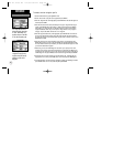
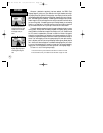
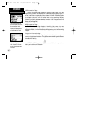
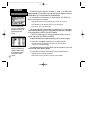
To view waypoint information:
1. Press MENU twice to display the main menu.
2. Highlight ‘Waypoints’ using the rocker keypad and press ENTER. One of the waypoint
information pages listed above will be displayed.
3. A series of tabs across the top of the page will indicate the other available pages.
Select the desired page using the rocker keypad.
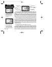
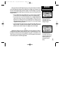
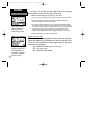
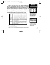
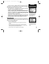
The Main Menu’s ‘Waypoints’
option allows you to view
database information for air-
ports, runways, comm fre-
quencies, VORs, NDBs, etc.
Select the desired waypoint
category by selecting the
corresponding ‘file tab’ at the
top of the page.
48
REFERENCE
Waypoint Categories
GPS III Pilot B2 4/1/99 2:02 PM Page 48