


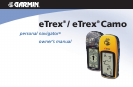


iv
CAUTION: Use the eTrex at your own risk. To reduce the risk of unsafe operation, carefully review and
understand all aspects of this Owner’s Manual—and thoroughly practice operation using the simulator mode prior
to actual use. When in actual use, carefully compare indications from the eTrex to all available navigation sources,
including the information from other NAVAIDs, visual sightings, charts, etc. For safety, always resolve any discrep-
ancies before continuing navigation.
CAUTION: IT IS THE USER’S RESPONSIBILITY TO USE THIS PRODUCT PRUDENTLY. THIS PRODUCT
IS INTENDED TO BE USED ONLY AS A NAVIGATIONAL AID AND MUST NOT BE USED FOR ANY PURPOSE
REQUIRING PRECISE MEASUREMENT OF DIRECTION, DISTANCE, LOCATION OR TOPOGRAPHY. THIS
PRODUCT SHOULD NOT BE USED AS AN AID TO DETERMINE GROUND PROXIMITY FOR AIRCRAFT NAVI-
GATION.
CAUTION: The electronic chart is an aid to navigation and is designed to facilitate the use of authorized gov-
ernment charts, not replace them. Only official government charts and notices to mariners contain all information
needed for safe navigation – and, as always, the user is responsible for their prudent use.
CAUTION: If the device is immersed, the electronics are protected, but the battery compartment may get wet.
Make sure the batteries and compartment are dry before using.
Warnings and
Cautions
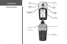
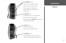
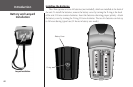
Introduction