


ix
Introduction
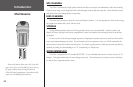
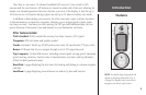
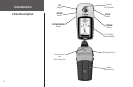
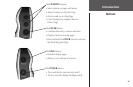
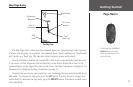
The eTrex is a six ounce, 12-channel, handheld GPS receiver. It has a built-in GPS
antenna and five user-buttons. All buttons are located on either side of the unit, allowing for
simple, one-handed operation that won’t obstruct your view of the display. It runs for up to
16 hours on two AA batteries during typical use and up to 22 hours in battery save mode.
In addition to determining your location, the eTrex can create, name, and save locations
in internal memory as electronic waypoints, allowing you to navigate back to those points
any time you want. And once you start moving, the GPS provides additional data, such as
speed, direction of movement, time and distance to your destination, and more.
Other features include:
WAAS Enabled: WAAS enabled for accuracy less than 3 meters, 95% typical
Waypoints: 500 with name and graphic symbol.
Tracks: Automatic Track Log; 10,000 point active track, 10 saved tracks (750 pts. each).
Routes: 20 Routes that let you navigate through a set of 125 waypoints each.
Trip Computer: 31 data field choices, including current speed, average speed, maximum
speed, bearing, elevation, location, time of sunrise/sunset, trip timer, and trip odometer.
Allows for dual position formats.
Hunt/Fish: A page displaying the best times for hunting and fishing at a chosen waypoint
and date.
Sun/Moon: A page displaying sun and moon rise and set by date and location.
Features
NOTE: You should always be prepared and
capable of navigating without the eTrex. It
is designed to augment other forms of basic
navigation, not entirely replace them.