


43
Appendix B
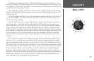
What is GPS?
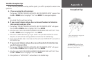
The global positioning system is a satellite-based navigation system consisting of a net-
work of 24 orbiting NAVSTAR satellites that are eleven thousand nautical miles in space and
in six different orbital paths. The satellites are constantly moving, making two complete orbits
around the Earth in less than 24 hours.
The orbital paths of these satellites take them between roughly 60 degrees North and 60
degrees South latitudes. What this means is you can receive satellite signals anywhere in the
world, at any time.
One of the biggest benefits over previous land-based navigation systems is GPS works in
all weather conditions. No matter what your application, when you need it the most, your
GPS receiver keeps working.
The GPS signal contains a ‘pseudo-random code,’ ephemeris (pronounced: ee-fem-er-is),
and almanac data. The pseudo-random code identifies which satellite is transmitting—in
other words, it is an I.D. code. We refer to satellites by their PRN (pseudo-random number),
from 1 through 32, and this is the number displayed on a GPS receiver to indicate which
satellite(s) we are receiving. Ephemeris data contains important information such as satellite
status (healthy or unhealthy), and the current date and time. The almanac data tells the GPS
receiver where each GPS satellite should be at any time throughout the day. Each satellite
transmits almanac data that provides orbital information for all of the satellites in the GPS
network.
Your GPS receiver reads the message and saves the ephemeris and almanac data for con
-
tinual use. Now, to determine your position, the GPS receiver compares the time a satellite
signal was transmitted with the time it was received by the GPS. The time difference tells the
GPS receiver how far away that particular satellite is. If we add distance measurements from a
few more satellites, we can triangulate our position. This is exactly what a GPS receiver does.
With a minimum of three or more satellites, your GPS can determine a latitude/longitude
position—what’s called a 2D position fix. With four or more satellites, a GPS receiver can
determine a 3D position fix which includes latitude, longitude, and altitude. By continuously
updating your position, a GPS receiver can also accurately provide speed and direction of
travel (referred to as ‘ground speed’ and ‘ground track’).