


FURUNO
RP-180
SP-1
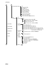
SPECIFICATIONS OF VIDEO PLOTTER
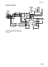
RP-180
1 GENERAL
1.1 Display Display of FR-1500 MK3 series Radar
1.2 Display Mode Radar picture overlaid on plotter picture
1.3 Presentation Mode North up (NU), True motion (TM), Course up (CU), Head up (HU),
Cursor Gyro (CG)
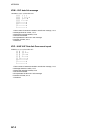
1.4 Display Range 0.125/0.25/0.5/0.75/1/1.5/2/3/4/6/8/12/16/24/34/48/72 (nm)
1.5 Projection Mercator
1.6 Usable-Latitude 80° or below
1.6.1.1.1 Coastline Data PMCIA type Furuno card and Navionics card or C-MAP, selectable
1.7 Track
Memory Capacity (pts)
3,000 for radar map 40,000 for track+mark, 20,000 for other ship track
Plot Interval Own ship: 1-60 s or 0.01 nm-9.99 nm, Other ship: 1-60 s
1.8 Mark Type Own ship, MOB, square, circle, line
1.9 Courseline Traced using data fed from position-fixing equipment specified
1.10 Alphanumeric Data Indications
Own ship’s position (L/L)
Cursor intersection (L/L)
Range and bearing from the origin mark to the cursor intersection
Range and bearing to waypoint
1.11 Alarm Waypoint arrival/anchor watch, XTE/border
2 AIS INDICATION
2.1 Symbol Sleeping/ Activated/ Dangerous/ Selected/ Lost targets
2.2 Number of Targets 1,000 max.
2.3 Data Indication Basic and Extended data
2.4 Track 10 or 5 points per target
2.5 Alarm CPA/TCPA alarm