


4–5
Erasing waypoints through the
waypoint list
1) Press [WPT RTE] and [4].
2) Press ▲ or ▼ to select waypoint to erase.
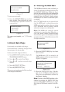
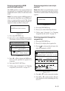
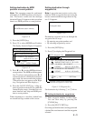
3) Press the [CLEAR] key. The message
shown in Figure 4-13 appears if the
waypoint is currently selected as destina-
tion, is part of a route, or is in the route
currently selected as destination.
This wpt is GOTO
This wpt is in registered route
This wpt is in selected route
1st line
Are you sure to erase ?
ENT: Yes MENU: No
Figure 4-13
Note: All waypoint marks (as well as all
other marks) and their data can be erased
collectively by clearing the Plotter
memory. For further details, see page 9-1.
4) Press the [NU/CU ENT] key.
Note: To cancel erasure, press the [MENU
ESC] key instead of the [NU/CU ENT]
key. The waypoint list appears.
5) Press the [MENU ESC] key.
4.4 Entering Routes
Often a trip from one place to another involves
several course changes, requiring a series of
route points which you navigate to, one after
another. The sequence of waypoints leading
to the ultimate destination is called a route.
The DD-80 can automatically advance to the
next waypoint on a route, so you do not have
to change the destination waypoint repeatedly.
The DD-80 can store 30 routes and each route
may contain up to 30 waypoints. Routes can
be registered while in the Plotter 1 or Plotter
2 display mode. Routes are mutually regis-
tered when the navigators are sharing data.
Entering routes
1) Press the [WPT/RTE] key.
2) Press [5] to select Route Planning. The
route list appears.
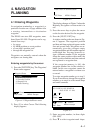
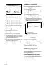
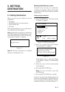
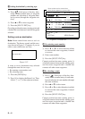
ROUTE LIST
ENT: Enter
MENU: Escape
No. PTS Total Dist. TTG Remarks
01
12D15H28M
1234 . 56 nm
D H M
. nm
30
UseFwd
02
2D08H35M
234 . 56 nm
25
03
*9D*9H*9M
*999. 99 nm
30
04
D H M
. nm
05
34D23H45M
6543 . 21 nm
30
06
: Edit: Route No.
Remarks
Use: In use
Fwd: Traverse waypoints in forward order
Rvs: Traverse waypoints in reverse order
Figure 4-14 Route list
3) Press ▲ or ▼ to select route number.
4) Press s.
The route planning/waypoint list window
appear as shown in Figure 4-15. The
waypoint list window lists the position and
data for each registered waypoint. No po-
sition or data appears for empty
waypoints.