


C-8
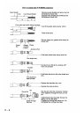
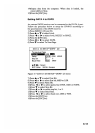
TLL: Target latitude and longitude
$--TLL, 00, 3445.678, N, 13521.234, E, abcd,
121530, T
a b c d d f g
h
R*A5<CR><LF>
a: Target number… not used
b, c: Latitude
d, e: Longitude
f: Target name… not used
g: UTC… not used
h: Target status… not used
i: Reference target… not used
j: Checksum
FURUNO proprietary sentences
AGFPA: Autopilot information from FURUNO autopilot
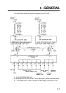
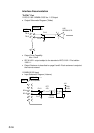
Port Input Output
DATA1, DATA2 NMEA 0183
Ver. 1.5/2.0
AGFPA, DBT, DPT,
MTW, TTL
IEC 61162-1/nMEA 0183 Ver.
1.5/2.0
AAM, APA, APB, BOD, BWC,
BWR, BWW, GGA, GLL, GNS,
RMB, RMC, VTG, WCV< WNC,
WNR, WPL, XTE, ZDA, ZTG,
Rnn, RTE, DTM
LOG PULSE DATA3 External MOB
Same as for DATA1.
General data DATA4 DGPS or general
data (selected
through menu)
IEC 61162-1/nMEA 0183 Ver.
1.5/2.0
AAM, APA, APB, BOD, BWC,
BWR, BWW, GGA, GLL, GNS,
RMB, RMC, VTG, WCV< WNC,
WNR, WPL, XTE, ZDA, ZTG,
Rnn, RTE, DTM
General data
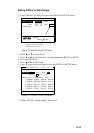
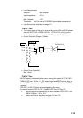
1) Input of lighthouse/buoy information: Floppy disk stored
lighthouse/buoy information is supplied from PC connected to DATA4
port.
2) Input of waypoint data: Connect YEOMAN to DATA4 port
3) Input and output of waypoint/route data