


1-4
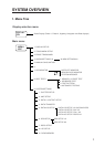
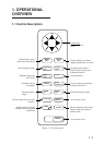
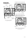
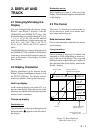
Plotter 1 display
234°
DGPS 3D
34° 23.456´ N 135° 45.678´ E
BRG
345°
BRG TO +
11.5
RNG TO +
nm
123°
CSE
[01]
30
40
20
50
H
WGS84
2.0nm
Cursor position or lighthouse
data
Own ship's
track
Own ship
mark
Course
bar
Bearing from own ship
to destination waypoint
GPS receiving
condition
Alarm
range
Range from own ship
to destination waypoint,
or bearing from own
ship to cursor
Course
Grid
Cursor
Speed, or range
from own ship
to cursor
Course
width
Course
Horizontal
range
Figure 1-5 Plotter 1 display
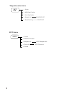
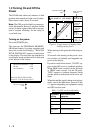
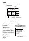
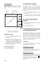
Plotter 2 display
DGPS 3D
34° 23.456´ N 135° 45.678´ E
[01]
30
40
20
50
H
2nm
Ship's position appears when cursor is off
WGS84
Figure 1-6 Plotter 2 display
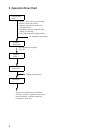
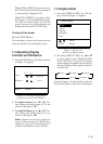
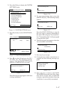
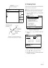
Highway display
234°
DGPS 3D
34° 23.456´ N 135° 45.678´ E
BRG
345°
RNG
123
12.3
SPD
nm
kt
CSE
[01]
H
[02]
1
1
nm
Position
Bearing from own ship
to destination waypoint
Course
Speed
Range from own ship
to destination waypoint
Course
width
Course
Own
ship's
track
Own
ship
mark
North
mark
Cross track
error scale
2
2
Figure 1-7 Highway display