


NKClearNavManual•Version0.5•July3,2008
Page32of86
Documents/Waypoints”directory.Thatwayyouandothersoaringpilotswillknowwhereto
findit.
2.3.4 ElevationData
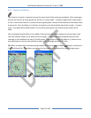
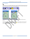
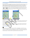
Elevationdataisusedtodisplayterrainelevationmapsonthemapscreenandisalsousedtodisplay
theAGL(abovegroundlevel)altitude.ThedataisavailableinlargeregionssuchasUSA,Europe,orthe
entireworld.Itispre‐loadedintotheClearNavandstoredontheprovidedUSBFlashDrive.The
elevationdataisstoredinthe“Globe”directoryontheUSBFlashDrive.
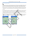
2.3.5 ShapeData(Cities,Rivers,LakesandRoads,etc.)
Shapedataisusedtodisplaycitiesandroads(“Culture”),andriversandlakes(“water”)onthemap.
ThedataisavailableinlargeregionssuchasUSA,Europe,ortheentireworld.Itispre‐loadedintothe
ClearNavandstoredontheprovidedUSBFlashDrive.Theshapedataisstoredinthe“Shape”
directoryontheUSBFlashDrive.
2.4 PuttingitAllTogether
2.4.1 HowitWorks
2.4.2 WhatitDoesDo
2.4.3 WhatitDoesn’tDo