


55
1. From the
NAVIGATION PAGE, press MENU|ENT or from the MAP PAGE,
press
MENU|MENU|↓ to ROUTE PLANNING|ENT.
2. Highlight
NEW ROUTE and press ENT|↓ to ROUTE END|ENT|↓ to ADD
FROM MAP|ENT. The Map Page appears with the cursor showing.
3. Use the Zoom and arrow keys to move the map and cursor until the
cursor is centered on the spot where you want the route to begin. If you
are starting at your current position or the current cursor position, you
are already at the starting spot.
4. Set the first waypoint by pressing
ENT. In this example, we moved to
the intersection of 11th Street and 145th E. Ave. to start our route.
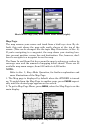
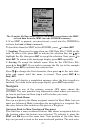
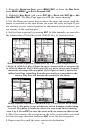
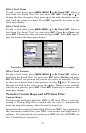
1. 2. 3.
Route creation sequence: (from left) Fig. 1. Set route waypoint (1) at
11th St. & 145th Ave. Fig. 2. Zoom in; move cursor north to set point (2)
at 145th & Admiral. Fig. 3. With point (2) set, move cursor east to mark
interstate on-ramp with waypoint (3). In figures 2 and 3, notice the
rubber band line extending from the previously set waypoint to the
cursor. This line will become the course for the route.
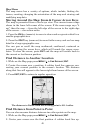
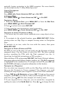
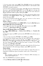
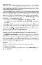
4.
5. 6.
Route creation sequence, continued: Fig. 4. Point (3) set at on-ramp
turn. Fig. 5. Waypoint (4) set at highway exit to frontage road leading
to river. Waypoint (5) ends the route at a tree stand in the hunting
area. Fig. 6. Press EXIT to save the route and you return to this screen.
5. Move the cursor to the next point in the route, a spot where you need
to turn or change direction and press
ENT to set the next waypoint.
6. Repeat step five until the route reaches its destination.