


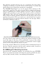
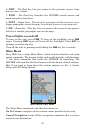
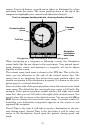

23
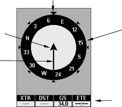
screen. Your trail history, or path you've taken, is illustrated by a line
extending from the arrow. The arrow pointing down at the top of the
compass rose highlights your current track (direction of travel).
Navigation Page, recording a trail, traveling east.
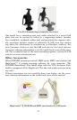
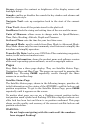
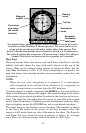
When navigating to a waypoint or following a route, the Navigation
screen looks like the one shown in the next image. Your ground speed,
track, distance, course and bearing to a waypoint, all can be shown
digitally on this screen.
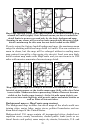
The current cross-track error is shown in the XTK box. This is the dis-
tance you are off-course to the side of the desired course line. The
course line is an imaginary line drawn from your position when you
started navigating to the destination waypoint. It's shown on the navi-
gation page as a vertical dotted line.
Lines on either side of the present position show the current cross track
error range. The default for the cross track error range is 0.20 mile. For
example, if the present position symbol touches the right cross-track
error line, then you are 0.20 mile to the right of the desired course. You
need to steer left to return to the desired course. You can use the
ZIN or
ZOUT keys to change the cross track error range. A circular symbol il-
lustrating your destination (waypoint) appears on the screen as you
approach the waypoint.
Travel Time is the time it will take to reach a destination at the pre-
sent closing speed. Arrival Time is the local time it will be when you
arrive at the destination, based upon the present closing speed and
track.
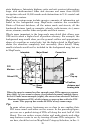
Compass
rose
Track or compass heading indicator, showing direction of travel
Navigation
information
data boxes
Present position
arrow
Trail line