


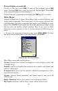
38
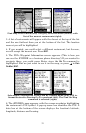
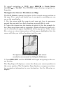
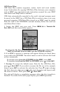
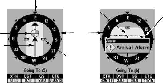
Navigate trail, navigation page (compass rose) views: Driver is east-
bound heading straight toward trail point 5 (left). The bearing arrow
shows the trail point is due east (straight ahead.) Driver (right) has
reached trail point 5 and must turn south to follow the trail. Arrival
alarm goes off and bearing arrow swings around to right (south), to-
ward the next waypoint, trail point 6. The iFINDER now shows navi-
gation information to point 6, which is 2.07 miles away.
3. When you reach your destination, be sure to cancel your navigation:
press
MENU|↓ to CANCEL NAVIGATION|ENT. A prompt will appear request-
ing confirmation. Press ←
|ENT.
Clearing a Trail
You can erase the current trail and automatically begin recording a
new one by using the Clear Trail command.
WARNING:
Clearing a trail will erase the trail from the iFINDER's
memory. You will not be able to back track the trail, if it
is erased. If you need to preserve the trail, switch to Ad-
vanced Mode and use the instructions in Sec. 4 for Cre-
ating and Saving a Trail.
1. Press
MENU|↓ to CLEAR TRAIL|ENT. A prompt will appear requesting
confirmation. Press ←|
ENT.
2. Press
EXIT to return to the main page display.
Transfer Custom Maps and GPS Data Files
Custom Maps:
Custom maps work only from a MMC or SD card. When a card contain-
ing a Custom Map File is loaded into the unit, the iFINDER automati-
cally pulls the map into memory when you turn on the unit.
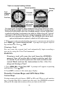
Trail
waypoint
symbol
Compass
rose
Bearing
arrow
Trail line
Present position
Cross track
error range
(off course
indicator)
Track or compass heading indicator