


50
eTrex Vista C
Using Routes
GPS Navigation
Methods of navigating to a destination:
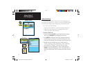
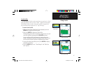
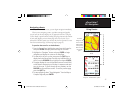
• When you activate the “Go To” button on the Information Page for a
User Waypoint or other Find Menu items, the eTrex Vista C creates
a straight path (point to point) from your current location to that
location.
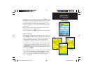
• When you press the “Navigate” button on a Route page, the eTrex
Vista C creates a route composed of several User Waypoints or
Find Menu items, with the last being your destination. It navigates
directly from point to point. Before each turn in the route a turn
page displays a guidance message and graphic of the turn. You can
view the turns at any time by pressing the ROCKER key Up or
Down arrows while the route is active.
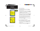
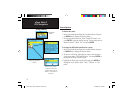
• These two navigation methods change when you select the “Follow
Roads” option from the Routing Setup Page. Both Go To navigation
and point to point routing become routes that use roads.
The routes use existing roadways (either those in the basemap or
from downloaded detail mapping) to automatically calculate a route
to your destination. Turns on roadways are added to the active route
page and is preceded by a guidance message with a graphic display
of the turn.
If there are not enough roads at your location to calculate a route, a
message appears to advise you.
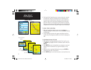
Go To (Distance)
Manual Routing
Auto Routing
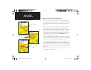
Direct Line Navigation
Navigation using Existing
Roadways
Navigation from Waypoint to
Waypoint
eTrex Vista C Owner's Manual Text.indd 50 8/12/2004, 9:17:20 AM