


9. INSTALLATION
56
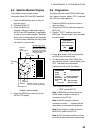
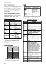
9.4 Initial Settings
This equipment can output navigation data to
external equipment, in NMEA 0183 format.
For example, it can output position data to a
radar or echo sounder for display on its
display screen.
Output data format, data sentences
NMEA 0183 version 1.5, 2.0 or 2.1 can be
selected from the I/O SETUP menu.
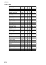
DATA1: Current loop data
With waypoint
AP
REM1 REM2
GLL
GLL GLL
VTG
GGA GGA
ZDA
VTG VTG
AAM
*2
ZDA ZDA
APB
*2
RMC RMA (Ver 2.0)
*1
BOD
*2
RMB
*2
GTD (Ver 1.5)
*1
BWC
*2
RMC
XTE
*2
RMB
*2
(1 s interval)
(1 s interval)
BWC
*2
(1 s interval:
Ver. 2.1
2 s interval:
Ver. 1.5/2.0)
*1
: Output when Loran C TDs are displayed.
*2
: Not output when no waypoint is set.
AP: Autopilot
REM1/REM2: Radar, echo sounder, etc.
DATA2: RS-232C level
With waypoint
AP REM
GLL GLL
VTG GGA
ZDA VTG
AAM
*2
ZDA
APB
*2
RMA (Ver 2.0)
*1
BOD
*2
GTD (Ver 1.5)
*1
BWC
*2
RMC
XTE
*2
RMB
*2
BWC
*2
*1
: Output when Loran C TDs are displayed.
*2
: Not output when no waypoint is set.
DATA2
nocaeBlanretxE
gnitteSrevieceR
nocaeBlanretnI
gnitteSrevieceR
tuptuO
AGG
KSM
tupnI
foatadnoitcerroC
nocaeblanretxe
reviecer
lanretnifotuptuO
s'reviecernocaeb
atadnoitcerroc
dnaatadnoitcerroc(
)SSMRC$
BEACON on WAAS/DGPS
SETUP menu set to
EXT
BEACON on WAAS/DGPS
SETUP menu set to
INT
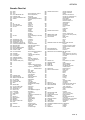
Data sentence description
Sentence Description
AAM Arrival alarm
APB Autopilot data (XTE and bearing to
waypoint)
BOD Bearing from own ship to
destination
BWC Range and bearing to waypoint
(great circle navigation)
GGA GPS position fixing condition (time
of fix, latitude, longitude, receiving
condition, number of satellites
used, DOP)
GLL Latitude and longitude
GTD Loran-C time difference
RMA Generic navigational information
(latitude, longitude, Loran-C time
differences, ground speed, true
course
RMB Generic navigational information
(cross track error, steering
direction, starting waypoint no.,
destination waypoint no., latitude
and longitude of starting waypoint,
latitude and longitude of destination
waypoint, range and bearing to
waypoint, range and bearing from
present position to destination
waypoint, velocity to destination,
arrival alarm)
RMC
Generic navigational information
(UTC time, latitude, longitude,
ground speed, true course, day,
month, year)
VTG Actual track and ground speeds
XTE Course error amount and direction
to steer
ZDA UTC time (day, month, year)