


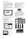

7. OTHER FUNCTIONS
38
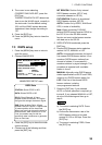
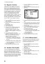
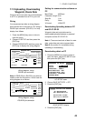
7.5 Magnetic Variation
The location of the magnetic north pole is
different from the geographical north pole.
This causes a difference between the true
and magnetic north direction. This difference
is called magnetic variation, and varies with
respect to the observation point on earth.
Your unit is preprogrammed with all the
earth's magnetic variation. However, you may
wish to enter variation manually to refine
accuracy. Set “BRG REF” on the PLOTTER
is set to “MAG” to use magnetic variation.
1. Press the [MENU] key once or twice to
open the menu.
2. Choose PLOTTER and then press the
[ENT] key.
3. Choose MAG. VAR.
4. Press the [ENT] key.
5. Choose AUTO or MAN as appropriate
and then press the [ENT] key. For
automatic magnetic variation, current
magnetic variation appears to the right of
AUTO.
6. If you selected AUTO, no further
operation is necessary; go to step 7. For
MAN, press the [ENT] key and enter
magnetic variation as follows:
a) If necessary, change coordinate from
east to west or vice versa by pressing
▲ or ▼.
b) Press ► to shift cursor, use ▲ or ▼ to
set value, referring to a nautical chart.
c) Press the [ENT] key.
7. Press the [MENU] key twice to finish.
7.6 Geodetic Chart System
Your unit is preprogrammed to recognize
most of the major chart systems of the world.
Although the WGS-84 system, the GPS
standard, is now widely used other categories
of charts still exist. Choose the chart system
used, not the area where your boat is sailing.
The default chart system is WGS-84.
1. Press the [MENU] key once or twice to
open the menu.
2. Choose SYS SETUP and then press the
[ENT] key.
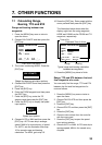
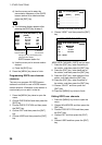
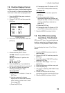
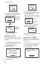
SYSTEM SETUP
LANGUAGE : ENGLISH
DATUM : WGS84
UNITS : nm, kt
TIME DIFF : +00 : 00
TIME DISP : 24HOUR
TEST?
SIMULATOR?
EXCHANGE BATTERY?
SYSTEM SETUP menu
3. Choose DATUM and then press the [ENT]
key.
4. Choose WGS84 (GPS standard), WGS72
or OTHER as appropriate and then press
the [ENT] key.
5. If you selected WGS84 or WGS72, go to
step 6. For OTHER, do the following:
a) Press the [ENT] key.
b) Use the cursor pad to enter chart
number, referring to the geodetic chart
list on page AP-3.
c) Press the [ENT] key.
6. Press the [MENU] key twice to finish.
7.7 Units of Measurement
Distance/speed can be displayed in nautical
miles/knots, kilometers/kilometers per hour,
or statute miles/miles per hour.
1. Press the [MENU] key once or twice to
open the menu.
2. Choose SYS SETUP and then press the
[ENT] key.
3. Choose UNITS.
4. Press the [ENT] key.
5. Choose combination desired; nm, kt; km,
km/h; sm, mph.
6. Press the [ENT] key.
7. Press the [MENU] key twice to finish.