


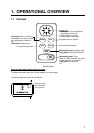
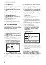

1. OPERATIONAL OVERVIEW
4
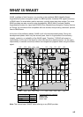
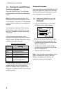
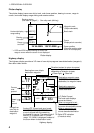
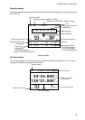
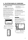
Plotter display
The plotter display traces own ship’s track, and shows position, bearing to cursor, range to
cursor, horizontal display range setting and receiver status.
D2D
[ 40 ]
n
m
12.0
n
m
34°44.000N 135°21.000E
X
Own ship mark (blinking)
Receiver status
(See table on page 2.)
Cursor
(Displayed six seconds.)
Waypoint mark
(Shape selectable)
Horizontal display
range setting
Range
to cursor*
Bearing
to cursor*
Boat's track
RNG: +
BRG: +
* = COG and SOG replace bearing to cursor and
range to cursor when the cursor is not displayed.
180°
Cursor position
(Own ship position when
cursor is not displayed.)
Plotter display
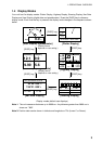
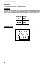
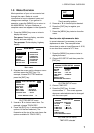
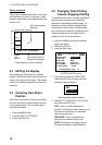
Highway display
The highway display provides a 3-D view of own ship’s progress toward destination (waypoint).
Nav data is also shown.
9.0
n
m
RNG
11°
SOG
n
m
N
Bearing from own ship to
destination waypoint
Speed
over
ground
0.3
XTE
0.05
BRG
COG
11°
k
t
12.5
Course
over
ground
CURSOR
Destination waypoint name
"CURSOR" (cursor-selected
destination) or waypoint name
Digital XTE indication
(in nautical miles)
[+]
0.5 0.5
Range from
own ship to
destination
waypoint
Analog XTE (Cross-track error) scale
Arrow shifts with boat's XTE. When the
arrow is aligned with the centerline
the boat is on course. The arrow blinks if
boat's XTE is greater than XTE scale
range. "N" (North) is displayed instead of
the arrow when no destination is set.
Destination waypoint
Moves forward as boat
nears destination.
Direction to steer (to return to course)
Appears to right or left of centerline
depending on direction to steer;
: Steer right, : Steer left.
I I I I I I I
∆ C (Delta Course)
The boat mark displays
course as follows:
When no waypoint is set;
The mode is North-up and
the arrow shows boat's course.
When a waypoint is set;
The arrow shows boat's
course towards destination.
Highway display