


-1.59-
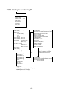
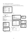
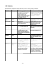
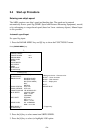
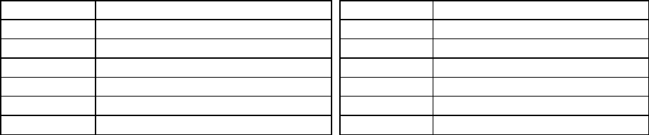
The table below describes which menu item adjusts the brilliance of which picture element.
Menu Item Functions adjusted Menu Item Functions adjusted
RINGS Fixed range rings EBL Electronic bearing lines NO. 1, 2
VRM Variable range markers NO. 1, 2 + CURSOR Trackball controlled cursor
CHAR Alphanumeric readouts MARKS Bearing scale
TRAILS Target trails HL Heading Line and stern marker
PLOT Plots for EPA and ARP-26 L/L Latitude and longitude grid lines
CHART Charts
Note: You should adjust the entire CRT brilliance by operating the BRILLIANCE control
before adjusting the respective brilliance levels on the BRILLIANCE 1 and 2 menu.
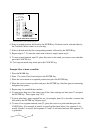
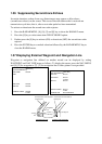
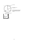
1.39 Display of Wind/Tide/Depth Information
Wind
Wind, oceancurrent and depth sounding data can be displayed in the text cell which is
normally used to indicate third target ship data. Do as below:
1. Press the NAV menu to show the NAV INFORMATION 1 menu.
2. Press [9] key twice to set WIND DATA ON and press the ENTER key.
3. Press [0] key to show NAV INFORMATION 2 menu.
4. Press [2] key twice to set WIND GRAPH ON and press the ENTER key.
Echo sounding depth and tide
1. Do the same to indicate ocean current graph and echo-sounding chart. Depth scales can be
selected among 10, 20, 50, 100, 200 and 500 m. The echogram shows the last 30 minutes
of depths along the ship’s track.
2. Press [0] key to show the NAV INFORMATION menu.
3. To indicate the date and time in UTC, press [3] key twice or three times to select UTC and
press ENTER key.
4. To indicate the local time, press [3] key twice or three times and press ENTER key twice.
Enter time difference between UTC and local time, followed by the ENTER key.
Note: Wind data and current data require the respective sensors. The depth data requires an
adequate echo-sounding equipment. The echogram shows the last 30 minutes of depths
along the ship’s track. Wind vector shows a direction from which the wind blows in,
relative to own ship heading, and labeled T *. Wind velocity is a true wind speed as a
result of compensating for own ship’s speed and orientation. Ocean current (tide) is the
direction to which the current is flowing away from os position, relative to north.
* T in this case means a true value meanwhile T denotes “relative to True North” in the
case of EBLs and target ship vectors.