


-9.5-
GLL - Geographic position - latitude/longitude
Latitude and longitude of vessel position, time of position fix and status.
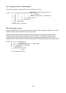
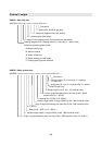
Mode indicator (See note on page 9.3.) *1
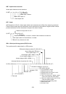
$--GLL, 1111.11, a, yyyyy.yy, a, hhmmss.ss, A,a*hh<CR><LF>
Checksum
Status (A = data valid V = data invalid)
UTC of position *2
Longitude, E/W
Latitude, N/S
*1: Eidition 2 only, *2: Not used
MWV - Wind speed and angle
When the reference field is set to relative, data is provided giving the wind angle in relation to the vessel’s
heading and wind speed, both relative to the moving vessel.
When the reference field is set to true, data is provided giving the wind angle relative to the vessel’s
heading and wind speed, both with reference to the moving water. True wind is the vector sum of the
relative apparent wind vector and the vessel’s velocity vector along the heading line of the vessel. If
represents the wind at the vessel if it were stationary relative to the water and heading in the same direction.
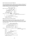
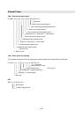
$--MWV, x.x, a, x.x, a, A*hh<CR><LF>
Checksum
Status (A = data valid V = data invalid)
Wind speed unit (K/M/N)
Wind speed
Reference, R = relative
T = true
Wind angle (0° to 359°)