


-9.4-
DBT - Depth below transducer
Water depth referenced to the transducer.
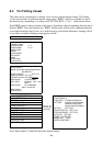
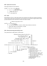
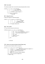
$--DBT, x.x, f, x.x, M, x.x, F*hh<CR><LF>
Checksum
Water depth, fathoms
Water depth, m
Water depth, feet
DPT - Depth
IMO Resolution A.224 (VII). Water depth relative to the transducer and offset of the measuring transducer.
Positive offset numbers provide the distance from the transducer to the waterline. Negative offset numbers
provide the distance from the transducer to the part of the keel of interest.
Maximum range scale in use *1
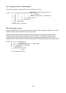
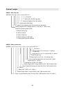
$--DPT, x.x, x.x, x.x*hh<CR><LF>
Checksum
Offset from transducer, in meters = distance from transducer to water-line
Water depth relative to the transducer, in meters
*1: Edition 2 only, however not used
GGA - Global positioning system (GPS) fix data
Time, position and fix related data for a GPS receiver.
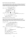
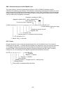
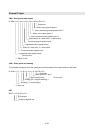
Differential reference station ID, 0000-1023 *1
Age of differential GPS data *1
Unit of geoid height, m *1
Geoid height (-999 - 0999) *1
Unit of antenna height, m *1
Antenna height (-9999 - 99999) *1 Checksum
Horizontal dilution of precision (00 - 99) *1
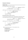
$--GGA, hhmmss.ss, 1111.11, a, yyyyy.yy, a, x, xx, x.x, x.x, M, x.x, M, x.x, xxxx*hh<CR><LF>
Number of satellite in use, 00-12
GPS quality indicator
Longitude - E/W
Latitude - N/S
UTC of position *1
*1: Not used
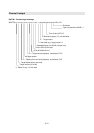
0= fix not available or invalid
1= GPS SPS mode, fix valid
2= differential GPS, SPS mode, fix valid
3= GPS PPS mode, fix valid
4= Real Time Kinematic. Satellite system
used in RTK mode with fixed integers
5= Float RTK. Satellite system used in RT
K
mode with floating integers
6= Estimated (dead reckoning) mode
7= Manual input mode
8= Simulator mode